Petrol Company Road Maps from Tunisia
|
 |
Tunisia was under a French protectorate from 1881 to 1956, when it gained its independence. Unlike its Maghreb neighbours, Tunisia has relatively encouraged the free market, so its petrol companies escaped nationalisation. In the 1930s, the petrol market appears to have been dominated by Esso (through the Sté Tunisienne des Pétroles), Shell and CIP (Compagnie Industrielle des Petroles, later acquired by Mobil). After the war, Total, Fina and BP entered the market, joined by Agip in 1960. BP sold its 49% of its chain to local partner, Setcar, in 1985 and the balance to Elf in 1992. Following Total's later purchase of Fina and Elf, Total's interest in the Elf network was also sold to Setcar, who introduced its own Staroil brand in 2005. Esso's merger with Mobil cut the number of main operators to just four; the merged chain was sold to Oilibya in the 2009.
The Tunisian Government wanted a local presence in the downstream market, so in 1963 acquired a 50% stake in Agip's operations, increasing to full ownership in 1975. Two years later it passed this to SNDP - the national oil company for distribution - who introduced the Agil brand. Agil was partially privatised in 2000, and now supplies just under 200 service stations.
Maps

|

|

|
 Esso map of Tunisia")
Rhorfas à Médenine
|

Café Maure à Sidi Bou Said
|

|

|
 Esso map of Tunisia")
|

|

|
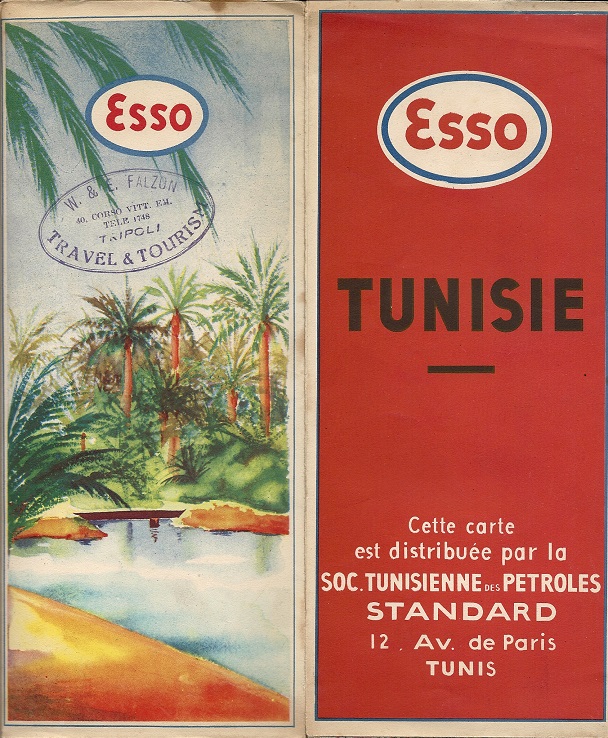
Esso has been the most consistent issue of maps in Tunisia. The examples shown here (top row, L-R) date from 1939, 1948, 1951, 1953, 1956 and (bottom row) 1959, 1965, 1971, 1976 and 1996.
Another 1971 map has the same cover design as 1976; both have an Arabic-only reverse similar to the 1965 design, but with a larger lighter blue Esso oval. the first three, taller maps have cartography by the French firm Blondel la Rougery at 1:800,000; the scenic ones use designs from the General Drafting Co of the US; in the 1960s/70s mapping passed to Britain's George Philip & Son. Only the 1995 issue used local cartography by the Office de la Topographie et du Cadastre (OTC).
Enlarge 1948 map, including graphic rear cover

|
The earliest example is a general map-guide under the patronage of the Tunis and Bizerte Chambers of Commerce, with mapping by the Automobile Club of Tunisia. The next two maps were produced solely for Esso by Blondel la Rougery (Paris). By 1954, a standard Esso Touring Service style was applied to all Esso maps; although the cartography was still by Blondel, they used General Drafting Co designs. The two right-hand maps on the top row are both copyrighted 1954, but from the map codes show that they actually date from December 1953 and March 1956 respectively.
Esso also issued a Tourist Guide in green covers, with no logo on the cover, but clearly stating "Édité par Esso Standard Tunisie S.A." It contains about 140 pages of sights to see along routes, with fold-out regional maps and was entirely in French. No cartographer was credited, although it was printed locally in Tunis.
|
General Drafting Co.'s designs influenced the look of the map as late as the 1976 issue, but in the 1960s were prepared by George Philip of London. From 1965 onwards the maps located Esso stations and the 1971 and 1976 editions shown here credit Esso Tunisia SA instead of one of the European cartographers. (Another 1971 issue, almost identical to the 1976 one, save for the absence of a cover price, actually still says that it was printed by George Philip, but is printed on poor quality paper like the other 1970s issues, has the 1971 date printed over a 1966 copyright date, and from minor changes to the maps can be seen to be intermediate between the 1971 and 1976 issues shown.) This 1966/71 map, and the 1976 example have reversible covers, with an Arabic outline map on one and the French language service station photo on the other. By 1995, the maps were printed on glossy paper and the cover design had been simplified (although the reverse was in French), as had the cartography inside, now attributed to l'Office de la Topographie et de la Cartographie.
Thanks to Richard Horwitz for the 1939, 1948, 1953 Guide & 1959 images, and to Jon Roma for the 1951 one.

|
Shell was a market leader across the Maghreb since the first filling stations were opened. This map from Foldex (France) SARL is dated 1938 and similar to those being sold by Shell's French operation at the time. It consisted of two sheets printed on thin paper, and glued and folded so as to open out into 10 folds. One sheet was dedicated to Tunisia at 1:1,000,000; the other to Morocco (at a smaller scale) and Tunisia. Each sheet had inset maps, described as "cartouches", and showing the areas around the four main cities of Algiers, Oran, Casablanca, Rabat and Tunis (but not Tangiers) at a larger scale - 1:300,000 for Tunisia, but 1:500,000 elsewhere. Although printed in France (and the copy shown here was sold in Britain for 5/-), the three Shell companies in the region were credited with having edited the map, to prove local knowledge.
|

|
After the war Shell continued to sell maps created for it by Foldex, as in this 1957 map of Algeria and Tunisia. Tunisia was at a slightly smaller scale 1:900,000 (vs 1:750,000), and there were larger scale inserts of the most populous region around each capital city.
Image courtesy Richard Horwitz |

|

|
BP and Mobil also sold fuel in Tunisia, with BP entering soon after the Second World War, and Mobil acquiring the CIP (Compagnie Industrielle des Pétroles de l'Afrique du Nord) interests. Both maps shown left are based on a Michelin edition and cover both Algeria and Tunisia; the Mobil map has reversible covers (with the other side shown on the Algeria page). The Mobil map is dated 1958 and the BP map is from a couple of years later. Mobil later moved to a local, anonymous production printed on poor quality paper - the map (right) dates from around 1970 - enlarge cover.
BP image courtesy Jon Roma; 1958 Mobil image courtesy Mark Greaves
|

|

|
Agip was a relatively late entrant to the Tunisian market and this map dates from 1974, the year before its outright purchase by the Tunisian government. The map itself folds out from within light card covers, which also hold a 16 page booklet, entirely in French. As well as a quite basic map of the country, marking Agip locations, there are 14 town plans and 8 circular tours, plus summaries of the history and gastronomy of Tunisia.
|

| 
|
After Agip sold its interests to Agil, only one map is known. Dating from 1988, it covers all of the country, although the front cover just has photo of Agil station at El Kantaoui is a resort area in central Tunisia, north of Sousse. The back has stations locations. The map measures 5x9 inches, at a scale of 1:1,000,000. Copyright is by Editions Turki - LeBardo, with the map printed at "office de la topographie et de la cartographie - Tunis". The legend is in Arabic, French and English.
Images courtesy Richard Horwitz
It is probable that the other international petrol companies, including Fina and Total (and possibly earlier CIP) would have issued maps. If you have a map from one of these companies, or could send me a scan of such a map, or - better still - the map itself, then please send me an e-mail!

Text and layout © Ian Byrne, 2006-17
All original copyrights in logos and map extracts and images are acknowledged and images are included on this site for identification purposes only.
