 2006 Road Maps
The glory days of the petrol company road map ran from the mid 1950s until the mid 1970s, when programmes were severely curtailed and cover prices rose sharply as oil companies were no longer prepared to subsidise the cost of their maps. However, there has been a long tail of map issues, and 30 years later, some issues are still being produced. This page will hopefully show some of the 2006 issues as they come out.
British large format atlases
Both these atlases were on sale in late summer 2005 but are identified as being the 2006 edition. They were both were prepared by Collins Bartholomew, but otherwise are quite different.
|
|
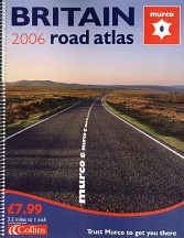
Murco, which has 350 service stations, often in local communities rather than on main roads, has issued an atlas for over 10 years. Sold for £7.99, it has 158 pages, with the main maps at 1:200,000 supported by district maps for major cities at 1:63,360 (1 inch to the mile). There are a further 65 city centre maps. Murco locations are not shown on the maps, but listed inside the rear cover. |
|
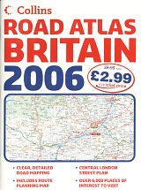
In contrast RoadChef is a chain that operates 22 motorway service stations, all selling major brand fuel, such as BP. Its atlas uses a reduced form of the same Collins cartography at 1:250,000, and is just 78 pages, with only one large scale map (of Central London). RoadChef's locations are however printed on the maps themselves, as well as shown schematically on the outside of the rear cover. This is RoadChef's first year with Collins; its 2005 map used AA cartography. Both the maps above measure approximately 485mm tall and so are shown at two-thirds relative scale to most of the cover images on this website. Morrisons supermarkets (which run a chain of around 275 petrol stations under their own brand) also issued a large format 2006 atlas (not shown) with cartography by the AA.
German maps and atlases
Aral and Shell remain significant sellers of branded maps in Germany.
|
|
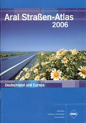
Aral's extensive mapping programme - in effect that of Busche, its long time partner - includes three items specifically dated for 2006. For €7,95 there is an A4 format softback atlas of Germany and Europe (left) with 176 pages, including 55 of Germany at 1:400,000 (with 25 city centre plans), Benelux at the same scale, Austria & Switzerland at 1:500,000 and the rest of Europe at 1:4mn. Aral also publish 2006 editions of a spiral bound atlas with maps at 1:200,000 and a box set of sheet maps of Germany and selected European countries. |
Shell maps - produced in partnership with Mairs - are available in shops as well as at Shell service stations, unlike those of Aral which can only be found at its garages. Shell's flagship offering is the large hardback Große Shell Atlas, dated as a 2006/7 edition. Shell also sell a softback A4 format atlas, slightly thicker than the Aral version (but costing €1 more).
Czech & Slovak issues
Many service stations in the Czech Republic and Slovakia sell a wide range of branded maps. As each map is a stock issue pasted into an oil company cover, the copyright date on the map may actually [pre-date the production of the map itself, if the base map is not updated each year.
|
|
|
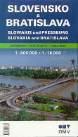
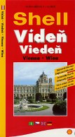
Both these maps carry clear 2006 copyright dates by Shocart, the Czech cartographer. Both were bought in June 2006 in Slovakian service stations. The OMV map covers Slovakia and Bratislava at 1:500,000 and 1:16,000, and features a Shocart stock image of the new bridge across the Danube in Bratislava; the same photo was used (with slightly different cropping) on a 2005 Jet map of the city. Map programmes extend into neighbouring countries, and the city of Viden/Vieden (in Czech; the reverse uses the Slovak Vieden ) is better known as the Austrian capital Wien (or Vienna). Shocart's high quality map is in four languages throughout - Czech, Slovak, German and English. |
Other brands that still regularly sell branded maps in their Czech or Slovak service stations include Agip, Jet and Slovnaft. The range of maps is extensive and typically includes:
- maps of the Czech Republic and Slovakia at two different scales;
- a combined map of both countries;
- city maps for Prague, Brno and Bratislava - generally with additional city/suburbs (Okoli) maps and small format city atlases, which may be spiral bound;
- maps of neighbouring countries (Germany, Poland, Austria, Italy, Hungary and Croatia/Slovenia);
- a map of Europe;
- national maps (Czech/Slovakia) backed with a "transit" map of Central Europe;
- large format spiral bound atlases of the countries at varying scales between 1:100,000 and 1:200,000; and
- a hardback atlas of Europe and the Czech & Slovak Republics.
Hungarian issues
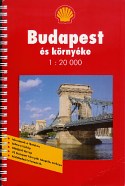
As of 2006, five of the main Hungarian petrol retailers appeared to be selling branded maps: Mol, Shell, Agip, OMV and the filling stations attached to Tesco hypermarkets. Almost all issues were stock titles from the three main commercial cartographers, with the exception of the Shell map shown right below, which was a station locator map sold at a low price (Ft.600, but possibly available free from some Shell outlets to customers buying fuel). This map, with a cover commemorating Shell's 75 years in the country, was produced for them by Top Gráf.
|
|
|
|
|
|
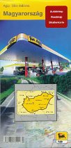
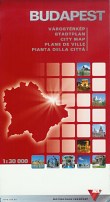
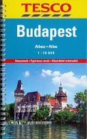
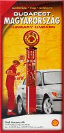
Agip is only known to have issued a single sheet map of the country by Cartographia. Mol, Shell and OMV all sold a mix of sheet maps and medium format spiral bound atlases of Hungary, Budapest and (except OMV) Europe. Tesco only sold atlases. Mol used Dimap cartography; Shell used Freytag & Berndt, and OMV and Tesco used Cartographia.
Polish issues
Jet and Shell filling stations in Poland sell branded road maps; most other brands only sell commercially published issues under imprints such as Demart, Pilot or Copernicus, although occasionally old BP maps (from 2000-1) can be found in BP stations. Orlen and BP have also issued road atlases (2001 and 2004) that can still sometimes be found on sale. Not all Jet and Shell maps are 2006 issues; on a recent visit most Shell city plans appeared to be dated 2005, and most Jet city plans were from 2004.
|
|
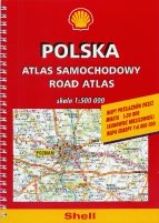
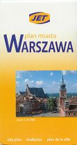
These maps were both produced by Daunpol. Left is a 2006 spiral bound road atlas of Poland at the scale of 1:500,000, covering the country in 56 pages of maps, slightly larger than A5 in size. There are also 17 pages of town plans (at 1:50,000) and a 15 page section of Europe at 1:4 million. An identical atlas is also available in Jet covers. The Warsaw map covers the entire city at 1:26,000, backed by a full street index (and city centre at 1:10,000, plus two maps of Warsaw environs at smaller scales). This was sold by Jet stations at the bargain price of Zl.6,50 (about €2). |
|
Station Locator Maps
One of the few remaining areas of relative activity in petrol company maps is the provision of station locator maps, sometimes for free distribution through service stations, or sometimes for mailing out to payment cardholders. These can be quite hard to track down; even when they are available freely, they are sometimes kept under the counter, or distributed in quite small numbers owing to the cost of production. Frustratingly, some also lack dates, so it's not clear if they are actually from 2006 or not. The Hungarian Shell map shown above is a station locator that, although not free, was at least clearly dated.
|
|
|
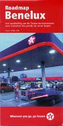
 The Texaco map of Benelux (left) is in some ways typical. The cartography is subservient to the marking of Texaco outlets; essentially the map is in white, light grey and yellow, except for Texaco stations, which are indicated by black number in a red oval. One side has the Netherlands and the other Belgium/Luxembourg; each side also has inset city maps and full list of locations. Probably designed for free distribution, this map was on sale for €0,50 in a Dutch Texaco station as late as October 2007. Cartography was by the Dutch firm Mapminded.
|
|
In recent years the map booklet has become at least as popular as folding maps for free distribution. This is probably because they are cheaper to print on standard paper sizes and then staple, than to print on a large map sheet and then fold; it also allows cheaper glossy paper to be used. A booklet format also allows for easier listing of service stations (or, as in the case of this 2006 Tesco booklet, all stores, whether or not they sell petrol). Finally, booklets also allow for full page adverts - this Tesco example only has in-house products (such as its 99 octane super unleaded, car insurance and photo processing) - although some have sold space to third parties. Oxford Cartographers provided the fairly basic maps, which take up just 20 of the 84 pages. |


All original copyrights in logos and map extracts and images are acknowledged and images are included on this site for identification purposes only.