 How accurate are road maps?
Comparing maps of Husbands Bosworth
Motorists rely on maps to be accurate representations of the roads on the ground, taking into account the scale at which the map is drawn. Although cartographers occasionally introduce deliberate errors, most of the time even the cheapest (or free) maps made available have met this aim admirably.
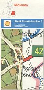
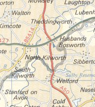
One map that allows us to test this - and how it has stood up to the test of time - is the 1974 Shell map series produced by George Philip & Son and covering Britain at the scale of 1:200,000 (approximately 3 miles to the inch). These maps, which were widely sold by Shell garages and can still be found quite easily in boxes of used maps, were noted for their clear cartographic style and relative large scale. (The equivalent Esso maps, although selling for a few pence less, were at the distinctly less generous scale of 1:316,800 = 5 miles to the inch.)
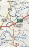
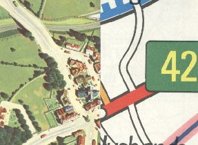
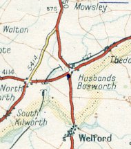
However one of the most notable features of the Shell series was the cover design which purported to show a section of the map next to an artist's impression of an aerial view of the same area, in a split screen format. In fact, the cover was drawn to a significantly larger scale than the map inside, and showed additional roads not on the actual map - as can be seen from the cover and map extract shown right of the section 3 (Midlands) which showed the area around Husbands Bosworth. Note how the cover, but not the real map, still shows the railway which had been closed to passengers in 1966. |
|
|
|
|
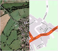
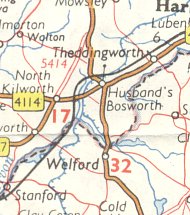
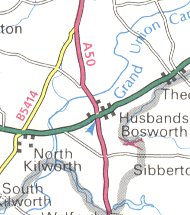
The image of Husbands Bosworth as it appears in 2004 shows how the area looks when viewed from the air, together with a modern computer generated map at 1:14,000. The conclusion is quite clear: that the Shell map was (and remains) reasonably accurate, but that the artist had taken significant liberties in drawing Husbands Bosworth from the air, notably making roads very much wider than they are in reality and increasing the size of buildings in line with the roads. Thirty years on, it's not possible to say if the field boundaries drawn in 1974 were accurate, but it seems likely that they were not, and were again simplified to make the image look clearer. And it is again notable how the artist added extra roads for the cover that are not shown on the map inside - including Mowsley Road, zigzagging North from the A427, and the two lanes running South (School Lane and Butts Lane).
In some respects this may not be typical, as most small English towns have expanded considerably more than Husbands Bosworth over the past 30 years. Indeed, the main change that would be seen on recent maps is that the road numbers have changed: the one running North-South through the village has changed from being the A50 to the A5199, and the East-West one from A427 to A4304. And it is perhaps unfair to try and compare a map at 1:300,000 with a recent street plan at 1:14,000!
Six further extracts from maps are included below - 5 from Shell, and one from Esso. If viewed on a 14 inch monitor, the screen image should around twice the size of the original map.
|
|
|
|
|
|
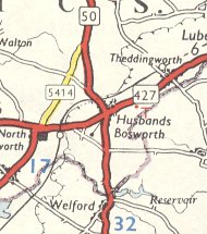
Top: Shell, ca1950 |
Top: Shell, 1961 |
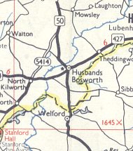
Top: Shell, 1964 |
The first map is unusually lacking in detail compared to some issues from Foldex, although it alone shows the railway tunnels. Shell's 1961 issue is unique in placing an apostrophe in Husband's. The 1965 Shell map is the only one that attempts to show the lanes referred to above, and may have been the reference for the artist on the later cover. Esso's map follows conventions established by the General Drafting Company and used on all Esso maps internationally, the dot in the circle marking the village indicated a population between 500 and 1,000. It is also the only map to mark Naseby battlefield so clearly, although the Foldex map does include it, just off the edge of the area shown. The earlier Shell-AA map comes from its Supermap series, and uses shading to indicate the height of the terrain; this helps users understand the landform, but impedes the clarity of the map. It is also the only example to name Sulby reservoir apart from the 1977 metric Shell-George Philip Printers version illustrated at the top of the page. Finally, the 1990 Shell-AA issue uses computerised cartography. |
||
Husbands Bosworth is in the English Midlands around 14 miles (22km) South of Leicester; for more information about the village today, visit the Husbands Bosworth website. Its name derives from Husbanders' Bosworth - ie. the part of Bosworth belonging to husbanders (farmers). This prefix distinguishes it from Market Bosworth, its near namesake West of Leicester, famous for being the location of the Battle of Bosworth. And although there used to be a filling station in the centre of the village, as far as I can tell it never sold Shell petrol.

Text and layout © Ian Byrne, 2004
All original copyrights in logos and map extracts and images are acknowledged and images are included on this site for identification purposes only.