 Belgian Independents since 1975
Octa+, OTA, Pollet, Power
A small number of Belgian independent petrol and oil companies have continued to issue road maps since the first oil crisis. There may be examples from other brands than those shown below: if you know of any, then please send me an e-mail.
Octa+
Brief History
| Becquevort Charbons started life in 1881 in the coal business, and later became an important gasoil dealer. As late as 1986 it started a network of service stations and in 1995 created the Octa+ name. By 2000 there were 56 service stations. In 1999 it merged with Avia Brouw, one of the 5 major Avia-partners in Belgium, which had previously controlled 27 Avia service stations. In early 2000 the combined company then took over the 115 remaining Burmah service stations, most of which had originally been small dealer-owned BP sites. (This represented Burmah's final exit from European petrol retailing.) The new group had a total of 198 service stations or around 4% of the Belgian market, which made them the largest independent in Belgium. The street atlas of Brabant shown here is essentially that same as that produced for Burmah in the late 1990s, and likewise comes from a series of four atlases, covering all major towns in Belgium. |
|

|
This map was prepared for AVIA/Octa+ card holders in January 2000 and shows service station locations from both brands - the Octa+ with the logo and AVIA with a blob; addresses for both are given on the reverse. Burmah stations are listed with Octa+ but marked with a "*". The map was prepared by Geocart-Claus NV. |
|


An AVIA version of this map is also produced and is shown on the AVIA page.
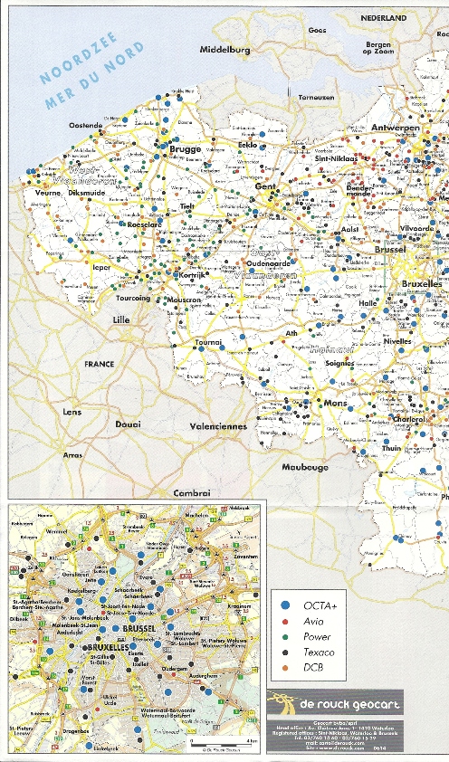
Octa+ still occasionally issues location maps for holders of its OCTA+pass card. The example shown right dates from December 2008 and is billed on one side as being of Benelux; the other refers just to Belgium but is almost identical in design. All the 1200 stations in the network in Benelux (850 in Belgium) that accept the pass are listed and shown on the map. As well as those branded Octa+, stations in the Texaco, Power, Avia and DCB networks are shown. Many independently branded sites are included within the DCB grouping, including the 31 stations of the Maes chain, 11 from DCB (possibly still using the G&V name), and smaller numbers from names such as VDB Energie, Heite, Taverniers and Vabo-Benz. In the Netherlands the brands are Texaco, Picobello and DCB itself (although these may actually sell Tamoil or Total fuel); in Luxembourg it is Gulf and Texaco. It is not known if Avia or Texaco versions of the map also exist. The map itself was created by de Rouck Geocart at a scale of 1:600,000. |
|

Am more recent Octa+ map from June 2014 is a much simpler affair, being a sheet of A3 folded down to C6 size. One side contains a just usable map of Belgium, drawn by de Rouck Geocart to around 1:850,000. It lacks road numbers, but marks all stations accepting the OCTA+pass with colour-coded discs, grouped by Octa+, Avia, Power, Texaco and DCB, as before. Although the reverse carries advertising it no longer lists station addresses, so there is no indication which brands are displayed by those in the DCB network. |
 |
 |
OTA
Brief History
OTA, which stands for Oil Trading Association, is an even smaller independent with around 5 service stations based at Merksplas in Northern Flanders. Although it entered into an arrangement with Esso, its stations still carried its own brand as recently as 2007. From left to right the maps shown below date from ca1970, 1987 and 1997. Unusually, the covers are only in Flemish with no French version.
|
|
|
The oldest map at 1:320,000 was specially printed for them by an anonymous cartographer (possibly de Rouck) with OTA's logo on the top left of the map. This was then pasted into light card covers with a place name index. The centre map is the standard Claus sheet 99 at 1:300,000, pasted into an OTA card cover. |


Pollet
Brief History
Pollet is a long-established Flanders independent which initially distributed Esso products, then later BP. Today it is Belgium's second largest independent (after Power) with around 50 outlets.
|
Pollet's first map was of Belgium in 1981 (left), using a design shared with BP. |
|
By 1992 (above), it was using custom covers - the front and rear being identical photographs. Only the spine indicated the location - in this case Italy! |


Power
Brief History
|
Power's origins go back to Britain in the 1920s, when Power Petroleum was established as an independent distributor. Acquired by Shellmex-BP in 1934, the Power name was subsumed into National Benzole when that was acquired by Shellmex-BP in the late 1950s, and its distinctive diamond logo ended up as the lower grade of fuel at National stations in the 1960s. After the divorce of Shell and BP in 1977, BP allowed one large independent distributor (Charringtons) to brand service stations with the Power name. |
 |
The map shown here dates from 2000 and has a card cover over a standard Geocart map at 1:250,000. No Power outlets are mentioned on the map or on the attached 'index of place names'.

|
In 2002 Power issued a map publicising its credit card (left) and marking Power, AVIA and Octa+ locations at which it could be used. Geocart-Claus drew the map at 1:535,000. In the next year, Power sponsored a map for the 'Ronde van Vlaanderen' cycling race, with one side marking the route and Power locations in Flanders, and the other side a larger scale map of just the route. |

|
Owing to its Russian parentage, Nafta maps are shown on a separate page.
Thanks to Michel Breugelmans for his help with these maps and the history of the companies.

Text and layout © Ian Byrne, 2000-15
All original copyrights in logos and map extracts and images are acknowledged and images are included on this site for identification purposes only.