 BP
BP
Maps from Germany
This page looks at road maps issued by BP in Germany.
Despite its name, the original company carrying the name BP in Britain was controlled by the German-owned Europäische Petroleum Union, which was the sole vendor of Shell motor spirit in the UK. Expropriated as foreign property during the First World War it was sold in 1917 to the Anglo-Persian Oil Company, in which the UK Government had bought a major stake.
Up to 1939
|
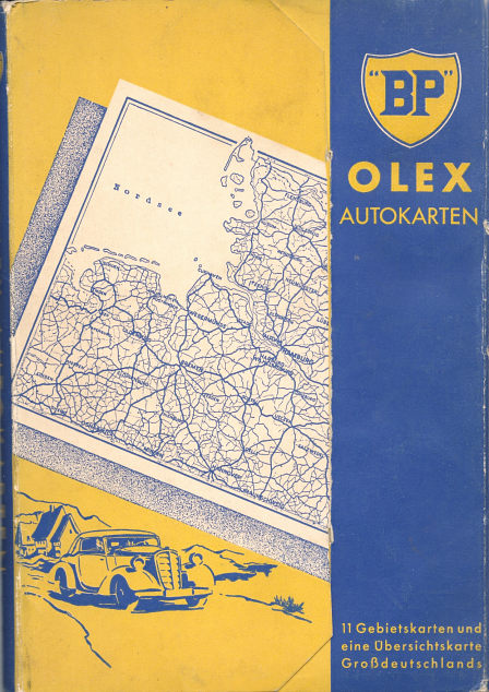
BP's earlier German connection did not prevent it from entering the German market itself in the early 1920s and towards the end of the decade it progressively took control of the former Oil Exporting organisation from Romania, which sold motor spirit in Germany under the name "OLEX". The most common pre-war BP maps are the 1930s sectional maps from Germany carrying both the BP shield and the Olex name. Although they carried the familiar BP shield, they were in Olex's blue and yellow colour scheme. The maps are undated, but can be roughly dated using the spread of the autobahn network and the changes to Germany's borders. The first one shown here (with a simpler typeface) is from about 1937. |
|

|
|
These maps were also sold in a set of 11 sections with an oversight map of the whole country, fitted into a light cardboard folder, shown left. The map on the right comes from 1939; as well as incorporating Austria as a tenth section, it can be dated from an advertising stamp announcing that from 15.5.39 BP-"Benzin" will be sold as BP-"Olex". Later in the year the covers were twice modified - firstly adding Bohemia (but retaining a border with Germany), then fully incorporating it into Großdeutschland. |
|


|
|
Also dating from the 1930s, BP-Olex produced a series of A4 format touring maps promoting their new fuel, folded into three, covering cities and adjacent areas. It is not known how many titles were available, but they certainly included Dresden, Sächsische Schweiz und Erzgebirge; Breslau, Eulengebirge - Grafschaft Glatz, Riesengebirge - Isergebirge; Mecklenburgische Seenplatte und Ostsee; and Harz-Touren und Göttingen-Eisenach. Each map marked the location of all Olex filling stations. Olex also sold an Olex guide to Bavaria and an aeronautical navigation chart, mounted on linen (but lacking a cover); neither of these referred to the BP name, but both are thought to date from after BP's acquisition of the company. |

1950s maps
|
|
|
|
|


BP maps from the 1950s are undated and, at a first glance, appear rather similar. However, they can be sequenced and given approximate dates from road construction. Running from left to right above, the earliest map above is probably from around 1952, when the major oil companies restarted mapping programmes. It can be distinguished by a large BP shield and light green colour to Germany on the cover. The next design, probably in use around 1954-5 has two versions, distinguished by the advertising slogan on the rear cover, which refers to Visco-static as well as Energol motor oils. Both cover designs are used with JRO maps at 1:750,000, covering West Germany on four sheets. The reverse of the map has a route planning map of the country, with an autobahn strip map down each edge.
By 1957 (and with an increasing road building programme, dates are easier to estimate) BP and JRO had chosen to move to a larger 1:500,000 scale, placing the main map on both sides of the paper. To compensate for this, West Germany now needed five sections, and an unnumbered route planning map was available separately. A cover price, of DM 0,20, was now shown.
The 1958 map was essentially the same, but the cover had to be redrawn to accommodate the revised BP logo. At the same time the gold of the earlier maps was replaced by the new BP yellow. Initially the white background to the BP shield was taller than it was wide, but it soon become square, and a DM 0,20 cover price was reintroduced.
All four maps marked towns with BP stations by underlining them and devoted the rear cover to a mileage chart.
|
In 1953 BP also sold an Autoführer (car guide) of the new Bundesrepublik (West Germany). This volume consisted of 368 pages, with the first two-thirds devoted to itineraries marked by a red strip map down the edge of each page. The rest of the volume decribed the larger towns, with each including a small street map marking BP locations. Each cover had a pocket, inside which was either a simple map of the main road network, or a map showing the location of the detailed itineraries. The cover shows an idyllic thatched Gasthof, with a couple being served food (two chickens!) and wine; a small BP sign is hanging from the eaves just above their car. JRO compiled the volume; the text was written by Eugen Roth, presumably a relative of JRO's founder, Johannes Roth. |
|

1960s maps
|
|
|
|
|
|
|


In the early 1960s BP moved to a smaller format of map, keeping the number of sections at 5, but numbering the national planning map as 6. This was also by JRO but at 1:1,250,000 and carried an inset of Berlin. The first two maps above date from around 1963 and 1964 respectively. All carried a mileage chart on the rear cover, but this was augmented by six different drawings mainly of people in sports cars in the latter year. The 1964 series, which like the other 1960s maps can sometimes be found in a clear plastic wallet embossed with the BP logo, also included a locator map showing where BP stations could be found on or close to autobahns.
Around the same time, BP started issuing city maps. It is not known how many cities were covered, but is known to have included at least Cologne (Köln), Hamburg, Munich (München) and Wiesbaden, created for BP by H. König.
The main maps also switched to H. König by around 1965-8 (year codes P, Q & S), when the final series above was published. Despite increasing the scale to 1:400,000, the maps were again confined to one side of the paper, through increasing the number of regional sections to six. This permitted town plans to be included on the reverse for the first time, as well as an autobahn overview map again highlighting exits with convenient BP stations. BP locations were marked on the city plans but not, for the first time, on the main maps. The 65/66 maps were priced at DM0,75; the 1968s at DM0,90.
1970s/80s maps
|
|
|
|
BP was still selling sectional maps from H. König with annual updates as late as 1978, as can be seen in this sequence of maps from 1976/7, 1977/8 and 1978/9. The "Neu" splash in 1978 advertised a new feature showing where there were plans to increase road capacity during the year. |


|
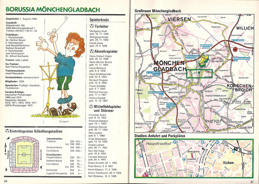
Although not actually a map, in summer 1978 BP gave its customers a free 52 page booklet called "Bundesliga Service 78/79". Prefaced by an article about the German football league, and listing the schedule for all matches (as well as those in the 2nd league North & South divisions, the main content was 18 double pages dedicated to each team. The left page had some historical information, a list of players, a cartoon and a plan of the ground including ticket prices. |
|
|


|
|
In the mid 1980s, a new unnumbered series in card covers was put on sale. JRO had again taken over the cartography, but the scale of 1:300,000 reflected the trend to larger scale maps amongst most of the major oil companies. |
|


|
|
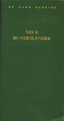
BP was still selling paper covered sectional maps as late as the 1990, after unification, with an expanded set of 10 sheets at 1:400,000. |
|


No BP maps are known from Germany carrying the helios logo that replaced the shield in 2000. Maps with the latter symbol are unlikely to exist as in 2002 BP acquired Aral, Germany's largest petrol retailer and took a decision to phase out the BP name in favour of the better known Aral image. However, around three service stations were left under the BP sign, to preserve its trademark rights, and these are marked on some current Aral maps with the sunflower logo.

Text and layout © Ian Byrne, 2005-16
All original copyrights in logos and map extracts and images are acknowledged and images are included on this site for identification purposes only.