Road maps from Sweden |
Up to 1950
Sweden's petrol industry started with Shell and Krooks (later part of Esso) around the turn of the 20th century; soon after 1910 the first petrol pumps appeared on Swedish streets. Many were made by the firm of Matthiasson, Andersson, Collin och Key - and so bore the name M.A.C.K. This abbreviation later became synonymous with filling stations in Sweden. However, by the 1920s, the Swedish market had little real competition with Standard Oil, Shell, BP, Gulf, Texaco and a local firm Axel Johnson (Nynäs) enjoying a massive 97% market share between them. During 1923, Swedish gasoline prices were nearly three times the world market price. So in 1926, some of the 80,000 Swedish motorists clubbed together to form the Bilagarnas Inkopscentral, a co-operative designed to cut the cost of motoring and sell gasoline and other products at more reasonable prices. As the full name is something of a mouthful, it was decided to sell gas under the abbreviation IC, and before long the simple globes with a red interlocking IC became a familiar sight on Swedish petrol pumps. In 1945, partly as a response to high world oil prices, a second co-operative was formed under the name Oljekonsumenterna - OK.
The other cut-price operator before the war was the Russian firm, NAFTA, which had first appeared in the 1920s. However in 1937 Gulf bought out the Russians as part of its European expansion and IC was left as the sole price leader.
 Image courtesy Jon Roma |
Very few branded road maps are known from Sweden before 1950, despite its relative prosperity and absence from the Second World War. |

|
Expansion in the 1950s and 1960s
The 1950s and 60s were a time of rising prosperity in Sweden, and oil companies made sure that their products were available in every town and village, leading to an extensive network of one filling station for every 800 or so inhabitants, a ratio surpassed only in neighbouring Norway. Costs were constrained by an extensive use of pre-fabricated stations to a standard design.
Around 1950, a new local champion was formed when the world's oldest company entered into a joint venture to sell petrol under the Koppartrans name. However this was acquired by Shell in following decade, as the first of many corporate realignments.
The two cut-price motorists' co-operatives - IC and OK - merged in 1963, but it wasn't until 1969 that the OK name replaced IC at service stations. Discounting also appeared in the form of Uno-X; originally a Danish concept, the rights to the name were auctioned and, perhaps unexpectedly, acquired in Sweden by the British company Burmah.

|

|

|
The three maps here all come from the late 1950s. Esso had moved to a single sheet format in 1953, and by this 1957 example had an image of part of Stockholm on the cover. General Drafting Co's designs were used, with a relatively small scale used to permit a pictorial guide, index and city plans on the reverse. In contrast Gulf used two sheets by Kartlitografen to cover the country, at the generous scale of 1:600,000. Shell solved the problem of a large country by putting its 1959 maps into a small format booklet at an intermediate scale. |

|

|

|

|

|
The maps above form a representative sample from the 1960s. Shell and its affiliate, Koppartrans, divided the country into two sections at 1,000,000, working the Kartografiska Institut (1964). Shell used this design from 1962-4; strangely the 1962 map can occur with the word "touring" in either red or black; later maps only had it in black. BP (1963) were able to use the same scale on a single sheet by simply making it larger; their choice of cartographer was Kartlitografen, who were also selected by Caltex. However Caltex's single sheet was at the smaller scale of 1:1,400,000.
|
|
|
 Few oil companies issued separate maps of Stockholm (although BP had produced a single sheet of town plans for Stockholm, Göteborg and Malmö in the late 1950s). OK was, as often, an exception to the rule - the map shown here dates from 1969.

Turmoil in the market: 1970s and 1980s
At the turn of the 1970s Sweden was probably over-provided with service stations, but there seemed to be an equilibrium. OK used its membership structure and customer loyalty to move into the market leader position (despite having fewer than half the number of outlets of Shell, which ran the largest chain). As elsewhere, this was disturbed by sharply rising prices; to keep costs pared to a minimum independent companies such as Mack and Maxi experimented with note-operated unmanned sites. These proved a runaway success; Mack was swallowed up by BP and by 1980 most BP stations had Mack pumps as well as their own. Maxi was acquired by Conoco's Jet chain, which also bought out the small company ARA.
This led to an unbalanced market, and suddenly all manner of deals were being struck. In 1982 Nynäs's stations switched over to Shell, and in 1984 Gulf sold its chain to the new Q8 company. In 1985 Mobil, which had been the smallest of the international names apart from Fina, sold out to Norsk Hydro, while Fina was sold to a fledgling national company, SP. 1987 saw Esso selling out to Norway's Statoil, while the decade ended with BP halving its chain through a sale of smaller outlets to Uno-X.

|

|

|
The 1972 Nynäs map here shows its old sign, soon to be replaced with a simpler design. The map itself is quite crudely drawn, but distinguished by including in the margins the coats of arms of all 111 Swedish kommunes and 24 läns. Since the 1950s, several companies had sold spiral bound atlases marking all their stations; Caltex was one such name and this was carried forward into Texaco (1975, left) and later Preem. |

|

|

|
Shell continued to divide the country into two sections, although with this 1979 map has a much less colourful cover than the 1962 example. OK used a similar size of map for their 1983 issue by Esselte Kartor, and is notable for large illustrations of Swedish wildflowers in the margins. BP stayed loyal to their larger format of maps, although by 1982 the Mack brand was also featured on the cover. But by 1984, Shell covered the country on one sheet in card covers using the Falk patent folding system, with advertising for other firms including Interrent, Checkers restaurants and Sara Hotels. |
Texaco image courtesy of Jon Roma |
|||
The 1990s remain unsettled
The deal-making of the 1980s continued into the new decade. A complex series of deals saw OK selling a stake to Arab investors, then losing some sites to Q8 and others to Texaco, before Texaco itself was sold to Saudi interests to form a new brand, Preem. But OK also gained the short-lived Svenska Petroleum (SP) chain to maintain its market position overall.
")
|
BP tried to rationalise its network by swapping sites with Statoil, but in 1994 threw in the towel, selling out completely to the Norwegian company. |
In the meantime unmanned stations continued their relentless rise, partly through Jet and other independent names such as Tapp, Din-X and Q Star, but also increasingly through the majors' own "minipris" stations. In 1996, Burmah sold its Uno-X stations to Hydro, and two years' later OK and Q8 pooled their interests into the oddly named OKQ8.

|

|

|

|

|
In the mid-1990s Swedish petrol companies continued to produce a wide variety of branded maps. Uno-X's maps were printed on semi-gloss paper and used modern computer cartography by Folia/LegindKort (and also marked Texaco sites). This was probably the last issue before it was bought by Hydro, who used KartCentrum for its quite small maps, but still at a scale of 1:1,000,000.
As noted above, some companies sold atlases as well as maps, and OK's 1995 thumb-index version is quite similar to the Texaco one from 20 years earlier. Q8's map also comes from Folia/LegindKort, but uses their more expensive QuickMap system to divide the country into horizontal slices. OK sold a similar map.
Even small companies needed to produce some means of encouraging drivers to visit their stations. In 1998 Din-X produced this map location booklet of Southern Sweden where their petrol stations are located, although it must be said that the maps were quite basic.
Into the 2000s
Source: Svenska Petroleum Institutet
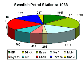
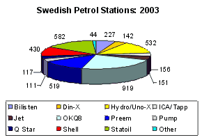
After all the changes in the 1980s and 1990s, the Swedish market was quite different. The pie charts above show a longer span of the 35 years from 1968 to 2003, during which period the number of petrol stations fell from 8,927 to 3,930. (This 56% drop is significantly less than that recorded in Britain, France or Germany over the same period.) Only Shell and Din-X remained as unchanged brands throughout the period; the colours in 1968 roughly broadly reflect the groups into which the brands have fallen. Of the newer names, Bilisten dates back to the late 1970s and was owned for several years by Shell, before Shell passed some of its smaller stations to the subsidiary and then sold it. Pump is owned by OKQ8 (formerly Q8) and concentrates on smaller, sometimes unmanned or discount stations. ICA/Tapp is associated with Hydro and specialises in supplying small sites next to village stores owned by the ICA co-operative.
In 2006 the Finnish company St1 entered the market, initially focusing on automat stations; it soon bought part of the Jet chain and much of Hydro/Uno-X from the newly merged StatoilHydro. After being on the market for a number of years, Shell sold its main chain to St1 in 2010, although the latter continues to use the brand under licence. Among the independents, QStar acted as a consolidator acquiring Pump and Bilisten, before being sold to DCC or Ireland in 2014.
 |
 |
 |
 |
 |
The five maps here are all from 2001. OKQ8, Shell and Statoil all placed Sweden onto a single sheet drawn by Folia at a scale of 1:1,000,000 and marking their own filling stations. OKQ8 opted for a variant on the QuickMap system which allowed the Southern region of Skåne to be at a slightly larger scale; the others are conventionally folded.
Preem stayed loyal to a more expensive atlas format, although - presumably to save costs - it was no longer spiral bound, but simply stapled. This permitted Liber Kartor maps to be included at the larger scale of 1:650,000, with 32 pages of town plans at the back which included brief descriptions of the main points of interest.
Jet's unmanned discount stations are marked on a single Kartcentrum map covering all of Scandinavia, at the necessarily small scale of 1:2.1million. However the map also includes small town plans for every locality with a Jet outlet.
As well as the examples shown above, Mobil IC and QStar have also issued maps or atlases in fairly small numbers.
There are around 40 other images of, or from, Swedish maps on this website. They include more maps from BP, Esso (1950s scenics), Gulf, Hydro, Koppartrans & Nynäs, OK, Preem, Q8, Shell (1990s) and Uno-X.
Please send me an e-mail if you can help me with any pre-war petrol company maps of Sweden, or with a map of the country from Bilisten, Fina, Murco, SP or any other brand.

Text and layout © Ian Byrne, 2003-14
All original copyrights in logos and map extracts and images are acknowledged and images are included on this site for identification purposes only.