Pratts and Esso Pictorial Plans

As well as traditional road maps, Pratts commissioned some 'pictorial plans' from the artist AE Taylor from 1930. These were issued in a number of formats, including as a bound volume after the Pratts branding had been replaced by Esso. In 1951, Esso sponsored a pictorial souvenir map for the Festival of Britain.
The 1930-2 Pratts Pictorial Plans
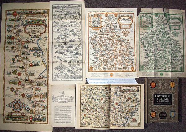
The 1932 series of maps were sold in several formats over a number of years, but all carry the same date. The most attractive versions were printed on heavy toned paper in 8 colours and were sold singly by Anglo-American Oil Co at a price of 1/- (5p) per section post free and were designed for framing. The Great North Road section (left) is one of the most commonly seen, and opens out to approximately 930x380mm (37in by 15in). Black and white reprints of Nos. 1 to 7, with descriptions of places interest, were available for 1½d (under 1p) post free. As can be seen these were about one third smaller. Plans 8 to 11, still printed in 8 colours but at a standard size of 30in by 20in, with descriptions by S.P.B. Mais, were sold for 6d (2½p) each. Mr Mais was described as being "the popular broadcaster on The Unknown Island". At least some sections were also sold in a two colour version (top centre and right) without the descriptions. The version printed in orange and black is earlier than the same map printed in green and black, as the former advertises Pratts Motor Oil, but the latter Essolube.
 |
After the Pratts name was replaced by Esso in 1936, the maps were reused in a bound volume titled "Pictorial Britain and Ireland". Sub-titled "The roads of Great Britain and Ireland shewing the principal places of interest", this was credited as being designed by Alfred Taylor, and described by S.P.B. Mais in a simple gazetteer format. The country was split into 8 chapters, each preceded by one of the pictorial plans. Four of the former series were dropped (the Great North Road, Bath Road, Watling Street and the New Forest), and the Islands of Britain was added (although it is possible that this was available singly). Black and white town plans were interspersed with the text: London was included with the Eastern Counties and Midlands, and described in just 3 lines, one less than the following entry for the village of Long Melford. |
The above image shows half of the West Country map, taken from the hardback volume published around 1936. Those below show a town plan of Lincoln and the Isle of Wight and Scilly Isles. | |
 |
 |
The individual sheets were: |
6. New Forest |
The 1951 Esso Festival of Britain map: "What do they talk about?"

|
Anglo-American contracted Professor E.G.R. Taylor (it's not known if he was a relation of Alfred) to supervise a map drawn by C.W. Bacon for the Festival of Britain in 1951. This was also available unfolded via the Geographical Magazine for 2/6d. It opened out to 18in by 27in and was printed on one side only. |

Text and layout © Ian Byrne, 2010
All original copyrights in logos and map extracts and images are acknowledged and images are included on this site for identification purposes only.