ESSO
Brief History:
Esso is the main brand used by Exxon Corp (formerly Standard Oil Company of New Jersey) in Europe, and has been a prolific issuer of road maps. As its history is relatively well documented, this web site will concentrate on the maps themselves. There are over 300 Esso or Standard maps shown here, with the approximate number of images shown in brackets (parenthesis), so they have been split into the following pages:
|
Esso Standard maps from 1920-51 (20) |
  Of Europe, but not from Europe. Two Esso maps of Europe produced for distribution "to our customers in the United States" by the General Drafting Co. The left is from 1960 and the right 1971. |
 |
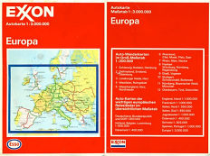
This 1988 map is something of mystery, as to why the primary branding is Exxon rather than Esso. It is unlikely that it was produced for sale in the USA where the Exxon name is used on service stations as all text is in German, although the example shown here was found in Britain. So it may have been a simple attempt to promote (or test) the Exxon name in Europe. Essentially it belongs to the German Esso series where custom covers were added to stock maps by Hallwag, here at the scale of 1:3 million (approx. 47 miles to the inch). Later German maps of Europe reverted to primary Esso branding. |
Navigation: Following the next page link will take you through the fifteen pages listed above in order. Although there are many images, most have been kept to as small a size as possible, so that the total size of all the images is still under 2Mb. The images shown are only a cross section of Esso maps available.
Special thanks to Stan DeOrsey for scanning some of his maps for these pages, and also for providing the detailed history of the Esso Touring Service.
Text & layout © Ian Byrne, 1999-2020
All original copyrights in logos and map extracts and images are acknowledged and images are included on this site for identification purposes only.

