ESSO

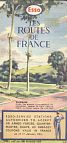
Road Maps from 1952 to 1961
The scenic map decade
With the opening of the Foreign Department of the Esso Touring Service in New York, Esso needed a complete set of maps of European countries in a more or less consistent format. On 15 March 1954, Esso opened its first European Touring Service office, in Paris. This was followed by a second office in Brussels four years later. Requests from Britain were usually processed by Paris, but even if an American wrote directly to one of the European offices, his reply would come from New York.
In most cases it used the same maps as were available at local Esso stations, but towards the end of the period there were a few Touring Service specials, including maps with Europe on one side and Britain, Germany or Northern Italy on the reverse.
|
|
|
|
|
|
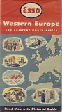
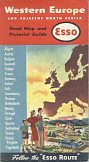
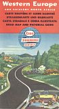
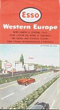
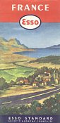
Esso's map of Europe was drawn in the USA by the General Drafting Co of New Jersey. On most issues, such as those from 1953, 1956 and 1960 (above, left to centre) it was backed by "a Pictorial Guide to Happy Motoring" - an outline map of the continent with several hundred small colour drawings of notable landmarks and customs. (See below for an extract of the Paris area.) Although the older maps appear to have only been issued with English covers, by 1960 a German language cover (and possibly others) were also available - an example is shown on the Esso Germany page.
Between 1955 and 1959, almost 150,000 copies of the Europe road map were printed in Britain by Edward Stanford in which it was backed by their own road map of Britain and Ireland, not the pictorial guide. This map was mainly used for distribution by the Paris-based touring service, rather than through UK service stations.
In 1960, two more versions were produced with country maps on the reverse. One featured West Germany on the rear (using the national map by Thiemig) and shared the same cover picture as the normal map. The third version had a specially drawn map of North and Central Italy on the reverse and the cover illustration was of Italy's Autostrade del Sole. This map was undoubtedly produced to aid motorists venturing to the Rome Olympics that summer, as it included large scale inset maps for Rome and the Bay of Naples (where the sailing events were held).
|
|
|
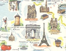
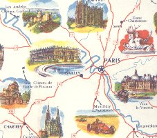
An outstanding feature of 1950s Esso maps was the pictorial guide, illustrating places of interest and often occupying the entire reverse of the map. Different maps used different drawings, as can be seen from the two extracts from around Paris shown above. On the left, a map of Western Europe has the "Arch of Triumph" (sic) and Eiffel Tower representing the city. However neither were used on the equivalent map of France, shown right, which concentrated on slightly less well known landmarks, such as the Eglise Saint-Pierre in Beauvais and Montlhèry Autodrome.
As there are separate pages on this web site for most other European countries, the rest of this page will look mainly at French and Austrian maps.
|
|
|
|
|
|
|


The fourth map is a throwback to an earlier period. At the start of the 1950s, Esso still used its pre-war cartography, but with the cover shown above. Although no longer used for most maps, it was retained as late as March 1957 for maps listing Esso service stations that could be used by members of US Forces stationed in the country; the service stations were listed on the reverse.
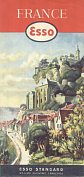
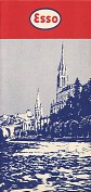
As far as is known, the only French cities for which Esso produced maps were Paris and the pilgrimage centre of Lourdes. The map of Paris with a watercolour image of Notre Dame on its cover dates from 1959. All five maps were prepared from Esso Standard S.A.F. by Blondel la Rougery, to designs (except for the forces map) from General Drafting Co.
In contrast the Lourdes map is an anonymous production, printed in just two colours and containing a basic street map marking Esso service stations and parking places in red. The reverse has a very small map of the Environs of Lourdes, again only really distinguishing those towns with Esso stations. The legend is given in five languages (French, English, German, Spanish and Italian). Most unusually, the name Lourdes does not appear at all on the cover.
Lourdes map image courtesy of Richard Horwitz
|
|
|
|
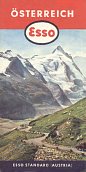
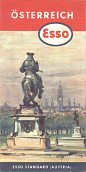
Esso's Austrian maps tended to use photographs instead of artwork on the covers. The first two shown here date from 1957 and 1959, but by 1960 they had moved to an art cover. Cartography was by Germany's Karl Thiemig at the quite small scale of 1:930,000, again to designs from General Drafting Co., possibly as Esso's Austrian chain had a relatively weak market position. |

|
|
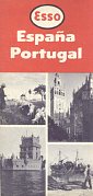
Esso did not sell fuel in either Spain or Portugal, so General Drafting Co. produced a small scale (1:2mn) map for use by the Touring Service. |
|
|

There are more pages devoted to 1950s maps with scenic covers shortly.
Next...>>
Special thanks to Stan DeOrsey for his information about the Esso Touring Service and General Drafting Co.

Text & layout © Ian Byrne, 1999-2005
All original copyrights in logos and map extracts and images are acknowledged and images are included on this site for identification purposes only.