 German independents of the 1950s & 60s: K-Z
Kraftex/Kraftin | Lotherol | Strato | SVG | Tramin | TS
A map from Klaus Salm is shown the Jet page, as the company was acquired by Conoco in 1971.
Brief History
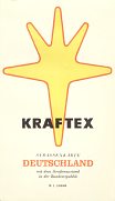
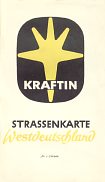
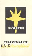
Kraftex was established by Werner Lücke in Düsseldorf in the late 1950s; by 1959 it listed 16 filling stations on the first of the maps shown below, roughly in a triangle bounded by Bonn, Düsseldorf and Mönchengladbach. It changed its brand name to Kraftin in the early 1960s, and grew steadily in size to a peak of 76 outlets at the end of the decade. Like several other German minnows it failed to weather the first oil crisis and the name disappeared during 1973.
Maps
|
|
|
|
All three maps shown are by JRO, with light card covers and typical JRO advertising on the rear of the map. The earliest Kraftex, from ca1959, covers all of W Germany at 1:1.1million. A ca1964 issue covers just the Rheinland where the brand operated at 1:300,000. In 1965 a pair of maps covered the country at 1:750,000: the section (Nord or Süd) was crudely rubber stamped onto the cover.
|
Brief History
Hermann Lother & Co. is based in Hamburg (although operates a depot in Itzehoe) and was established in 1935. It opened its first service station in 1956, and still supplies a small number of filling stations under its own (Lotherol) brand. In the 1970s Lotherol expanded by buying the regional independent Nordoel and in 2005 added a third brand to its stable: LTG. Lotherol also distributes petroleum products for Shell (formerly DEA); in all it now supplies around 90 service stations under the four brands.
Maps
|
(front)
|
(ads on rear of map)
|
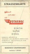
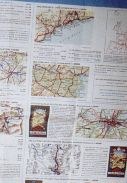
Lotherol card covers were added to this early 1960s JRO-Verlag map of NW Germany at scale of 1:500,000. The same cover design is known on another JRO-Verlag map of the whole of West Germany at scale of 1:1,100,000. Both maps were printed on a single side, with the reverse given over to a large array of adverts for other JRO maps and atlases, a globe and a even two headscarf maps - see full size extract from adverts.
Rear of map photo courtesy of Alexander Drews.
|
|

|
Strato Kraftstoffe is another firm about which nothing is known, other than the information from this map. No company name or address is shown; and as the map covers all of West Germany Strato could have been based anywhere. The only clue is that the map was found near Frankfurt, some 45 years after it was printed by Hans König in the same city. (The map is undated, but shows the autobahn network at a stage intermediate between the 1959 and 1960 Esso maps). The slogan Kosten sparen - Strato fahren (loosely Save money - go with Strato) is repeated on the rear cover.
|
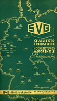
SVG stands for StrassenVerkehrsGenossenschaft, and is used by regional traffic cooperatives that support the transport and logistics industries. The group has traditionally included a bank and insurance company, but the most visible part of the business has been for fuel payment cards, which were widely used by commercial vehicles. As an adjunct to this business, some of the regional SVG operations also operated service stations (a bit like US Truck Stops), mainly close to autobahn exits. Traditionally these carried SVG's own brand of petrol, but in recent years over half the locations have switched to major brands such as Shell, Aral or Agip. The SVG logo generally used on service stations is still the same as that on the older map shown below left, but with brighter colours.
|
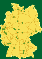
On a ca1957 Falk Auto-Atlas of West Germany the front cover located the 27 SVG stations. Like other Falk maps of the era, it is really a patent cut map of the country, pasted into a light card cover, with a 56 page gazetteer pasted into the front cover. West Germany was covered at 1:650,000 with insets of major cities and neighbouring countries. The 29 stations operating 50 years later (far right) show a remarkably similar distribution, even though two are in the former East Germany and only 13 carry SVG branded petrol.
(Image based on a web map of SVG stations as of June 2007)
|
|
|
|
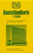
This other map (right) was issued soon after 1970 by the Rheinland-Pfalz SVG, and features the affiliated Bank für Wirtschaft u. Verkehr in Koblenz on the cover. This is a conventional JRO map in light card covers of West Germany at 1:750,000, with 2 advertising panels, one of which promotes SVG fuels and lists the addresses of the 5 SVG filling stations in Rheinland-Pfalz. The cover logo is different from that used on filling stations. SVG's Rheinland stations now sell Shell branded fuel.
Enlarge map
1957 image courtesy Richard Horwitz
|
|
Brief History
Tramin GmbH operated a small chain of filling stations from at its base at Mülheim-Ruhr in the 1960s. It appears that it was decided to expand the company, so it was re-incorporated as a public company in Berlin in 1972 under the name Tramin Transport- und Mineralöl AG, moving back to the Ruhr (Wesel) in 1975. The Tramin network expanded to maximum of 72 service stations and share certificates from this period (notably a 1981 issue) can be found for the public company. In 1983 the company filed for bankruptcy. However the Tramin name continued to be used on a small number of filling stations, and a couple survive to this day.
Maps
|

|
|
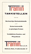
JRO overprinted their stock map of the Ruhrgebiet & Mittelrhein for Tramin around 1967. The front cover carries no logo, but space from the service station to affix their stamp, above the words TRAMIN G.M.B.H., Mülheim-Ruhr.
|
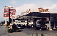
This May 2003 photo shows the Tramin station on Kölnstraße, Mülheim-Ruhr; note how the logo is very similar to that used in 1967.
|
|
|
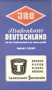
Tankdienst Sengeisen was a tiny company, listing just three TS branded service stations on the rear cover in towns North of Frankfurt. The map was issued around 1962, using a stock JRO map of Germany at 1:1,100,000 in a light card cover overprinted for TS. As with other JRO issues of the era, the reverse of the map was given over to advertising JRO's products, as shown on the Lotherol example above.
|
Text and layout © Ian Byrne, 2000-17
All original copyrights in logos and map extracts and images are acknowledged and images are included on this site for identification purposes only.