Dating early Gulf Road Maps from the USA
Many early Gulf Road Maps are either undated or were updated in subsequent years while retaining an earlier copyright date (generally 1916). This page indicates how to date these early Gulf maps.
|
In 1915 the Automobile Blue Book Publishing Company (AB) published Gulf maps and distributed them in their books. Gulf also distributed maps at their stations. Those which were in the books were bound in and have round corners like the books; those distributed by Gulf are folded in thirds. The book maps are not considered in the list of station maps which follows. From 1922 to 1926 Gulf maps were produced by Rand McNally (RM) after which the newly established H.M. Gousha took over. Unless otherwise noted all covers are printed in blue and orange. AB map titles read only the name of the areas or state covered; RM titles in the top box read "BLAZED TRAILS in ... follow the symbols on the posts". |
|
Summary of Front Cover Designs
 This is map with the most common cover design (B) dates from 1922, as it refers to Blazed Trails and has oil changes at every 1000 Miles in the bottom box. |
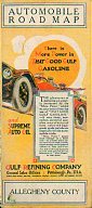
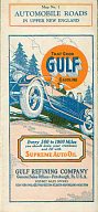
Cover design A: picture of a car with three people in it; no trees in background; orange disk has nine words in it; box at top reads "AUTOMOBILE ROAD MAP"; map title in box at bottom; portion of car is covered by a vertical box; colours of orange and blue on yellow. Used by AB only. Cover design B: picture same as above, orange disk has 13 words in it, box at top contains title, box at bottom reads "Automobile Road Map", colours are orange and blue. Used by AB and RM. Cover design C: picture of a car with two people in it, large post/sign device in foreground with words "Cross Roads" at top of it, trees in background; orange disk reads "That Good GULF Gasoline". No box at bottom. Used by RM only. Cover design D: picture of a car with three people in it, trees in background, orange disk reads " That Good GULF Gasoline ". Used by RM only. |
|
Chronological List 1914 - no cover seen, published by William Akin. 1915 - AB cover A; vertical box has 26 lines of text, copyright is 1915. 1916 - AB cover A; for state maps - same as 1915 only vertical box has 24 lines of text, Copyright is 1916.
MAPS DATED 1916 ARE ASSUMED TO BE REPRINTS UNLESS THEIR COVER IS DESIGN A.
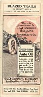
1917 - AB cover B; vertical box has nine lines of text with last line reading "carbon.", Supreme Auto Oil underlined twice, black and orange colours, no copyright date. 1918 - AB cover B; vertical box has nine lines of text with last line reading "free carbon.", blue and orange colours, dot over "i" in "Automobile" in bottom box is square, copyright is 1916. Rear cover has article headed "The Carbon Theory Exploded". 1919 - AB cover B; same as 1918 only dot over "i" in "Automobile" in bottom box is round (all letters are in a different type style), no copyright date. Rear cover is headed "SUPREME AUTO OIL" 1920 - AB cover B; almost the same as 1919 only diagonal lines shade vertical box border, copyright is 1916; the cloud is also slightly different from 1919. 1921 - AB cover B; bottom box begins "Every 1000 Miles...", black and orange colours. |
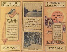
Two of the 1916 maps (images courtesy Dave Leach). Above is a regular state map, of New York, showing two photographic images (described as being "where sylvan lakes abound" and "winding and secluded drives"). The orange disk slogan "There is More Power in That Good Gulf Gasoline" has the initial letters highlighted in orange.
|
1922 - RM cover B; bottom box begins "Every 1000 Miles...", title begins "BLAZED TRAILS...", black and orange colours.
|
1923 - RM cover B; bottom box begins 1924 - RM cover C. 1925 - RM cover D; cover title reads "BLAZED TRAILS..." 1926 - RM cover D; cover title reads Advertising on the back and inside cover varies within the same year and has not been found to be a good indicator for dating the map. Beginning in 1927 Gousha produced Gulf's maps and their standard dating code was used (A for 1927, etc.). |
|
|
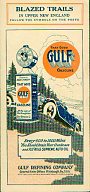
| Two Upper New England maps, dating from 1924 and 1926 (cover designs C & D). Images courtesy of Stan DeOrsey | ||
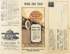
In the early years Gulf produced nine state or regional maps (NY, NJ, New England, PA, TX, Southern States, Middle West, Transcontinental and the Philadelphia Pike), but additionally there are a number of tour guide type maps prior to 1921. These are called "Week End Tour" or "Half Day Tour" in the title in place of "Automobile Road Map". All prior to 1921 are undated and the publisher is unknown. Beginning in 1921 a code number is often printed on the map. This number is month, day, year, and quantity printed (in thousands).
This page is based upon an article originally written by Dave Leach, and published in Check The Oil! magazine in January 1995, which was in turn based upon a 1982 article in The BaseLine, written by Stan DeOrsey with help from Dave Prentice.

Text © Dave Leach 1995; HTML realisation © Ian Byrne, 2001
All original copyrights in logos and map extracts and images are acknowledged and images are included on this site for identification purposes only.