 WESTFALEN
RÜCKWARTH, DEA/Casati u. Lederhausen
Brief History
Westfalen AG was established in 1923 in Münster under the name Sauerstoffwerke AG, specialising in industrial gases. In 1927 it opened its first filling station selling Westfalin and Westral products. Over the next decade it expanded its network to around 100 outlets, and after the war concentrated on developing full service stations, sometimes with associated parking garages.
Rückwarth was one of the larger West German independent petrol distributors, supplying around 250 outlets in the early 1960s. Despite acquiring the 83 service stations of Emhagol in 1970, along with many other firms its numbers fell sharply as the West German market consolidated in the 1970s and 80s.
In 1989 Westfalen acquired Rückwarth but it was only in July 1992 that its 62 filling stations were merged with the 183 strong Westfalen chain and the Rückwarth name was soon discontinued. Two years later, the 34 North German stations supplied by Casati & Lederhausen GmbH & Co. of Oldenburg were added, followed by 15 from Salim in 1997.
Today, Westfalen retains an important gas business, as well as supplying around 180 service stations in North & West Germany.
Road maps
 |
 |
 |
|
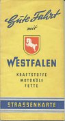
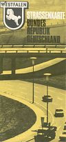
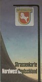
Probably dating from the late 1950s, the first Westfalen map shown was produced by Falkplan in sections at 1:250,000. The next example is dated 1967, and is straightforward Ravenstein map at 1:1,000,000 with eight small city maps included. The final example is probably a little younger and was produced by JRO at 1:400,000: unlike the earlier maps it only covers Westfalen's main marketing territory of North West Germany. It is unknown if, but unlikely that, Westfalen also sold maps covering other sections of West Germany.
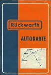
The 1960s Rückwarth map has a fairly simple cover, with the brand's main area indicated by a cross linking Kassel, Hannover, Dortmund and Osnabrück at Bielefeld.
 |
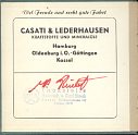 |
Casati & Lederhausen were for many years a branded distributor (jobber) of DEA products. They sold the small cloth bound DEA "Auto-Atlas" that was, in fact, a cleverly folded and cut sheet map of Germany at 1:750,000 by Falk-Verlag. The cover (far left) was the normal dark green of DEA, but the flyleaf of this 1962 map carried Casati & Lederhausen's details, with their four depots at Hamburg, Göttingen, Oldenburg and Kassel. |
Although no more recent Westfalen maps are known, a 1998 map booklet issued by Agip does show and list all Westfalen locations, as the companies had a reciprocal fleet card scheme.
Westfalen images courtesy of William Phillips.

Text and layout © Ian Byrne, 2001-6
All original copyrights in logos and map extracts and images are acknowledged and images are included on this site for identification purposes only.