 Errors on oil company road maps
Errors fall into two categories: accidental errors, where a mapmaker through carelessness, or a lack of information, has introduced a mistake onto a map, and deliberate errors.
Deliberate Errors
It may seem unlikely that cartographers would deliberately include errors on their maps, but this is actually quite widespread and used as a trap in case anyone should copy their maps without acknowledgement. British newspapers reported in March 2001 that the Automobile Association (AA) had agreed to pay Ordnance Survey (Britain's national mapping agency) a sum of GBP 20,000,000 (then worth US$ 29,000,000) in an out-of-court settlement for illegally copying their maps. Ordnance Survey revealed that they do indeed include small deliberate errors on maps including:
- an extra stream tributary
- imaginary farm outbuildings
- tiny kinks in rivers
- exaggerated curves in roads
- missing apostrophes
As a map collector, it is very hard to find these deliberate errors; indeed the quality of most European maps is so high it is hard to find any errors. Even when something strange is found on a map, it is not usually possible to determine if it is a deliberate or accidental mistake.
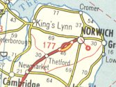
This is the strongest candidate for a deliberate mistake that I know of on a European road map. It comes from the 1961 reprint of Shell's "Taking the car" map of Europe, and although printed by Rotopress of Stuttgart, draws on original cartography by Mairs. A motorway bypass is quite clearly shown on the A11 road between Thetford and Norwich, roughly where the Wymondham bypass is today. But this road has never been a motorway, and the Wymondham bypass was only built in the 1990s, over 30 years later. This bypass was not shown on the 1959 or 1964 printings. |
|
Perhaps there is an unwritten agreement between cartographers about where to place their deliberate errors. For on the 2004 AA Road Atlas (used by Morrisons, among others, for its house map) the A11 bypass to neighbouring Attleborough is clearly shown as dualled, although in practice this was not done until around 2010. This error was corrected on more recent maps.
Another candidate for a deliberate error comes from the 1962 Europa Strassen Führer touring guide from the Esso Touring Service in Germany. This booklet of strip maps, which was also available in English and other languages, used local spellings of placenames throughout, so that the maps were identical in the English and German editions. Except... Torquay in Devon is rendered as "Torquai" in the German, but not the British, printing. As far as I can tell, the Germans do not have their own name for the town, so I suspect that this is a small yet deliberate error. |
|
Accidental Errors
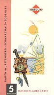
Possibly the most fundamental error is to print the wrong cover onto a map! |
|
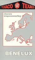 |
Geocart appeared to have made an even more fundamental error in this 1987 map. Although the cover states that it contains a Texaco map of the Benelux countries, the map pasted inside is Geocart's map of France, including a 47 page index to French place names. Texaco do not sell petrol in France, and it is not known if the Belgian or Dutch Texaco subsidiaries would have commissioned a map of France (although two of their main rivals, Shell and Esso, have done so). |
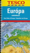
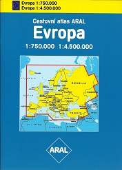
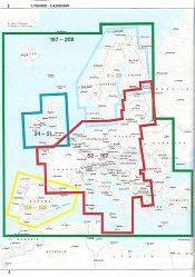
Another cover error, but semi-intentional. Aral's undated (but circa 2001) Czech language atlas of Europe was made of of a bespoke card cover over a stock Mairs road atlas of Europe. The covers were almost certainly printed separately and clearly show the scope of the maps as extending to include Russia in Europe, all of Turkey and the Ukraine, and parts of Syria, Georgia and Kazakhstan. This may have related to an earlier version of the atlas, for the actual maps inside - as shown on the key page - included none of Russia or the last three countries, and only the Western halves of Turkey and Ukraine. The parts of Greece shown at the larger (1:750,000) scale are just plain odd. |
 |
 |
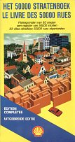
An equally annoying production error found its way into the 1986 Belgian Shell street atlas "Le livre des 50000 rues". This intended to include street plans for 83 towns across Belgian, spread over 86 double pages of maps. I have two copies of this atlas . One is correct, but the other pages 8-22 omitted completely, but 23-42 bound into the atlas twice. This means that maps for Antwerp, Arlon, Ath, Bastogne, Berchem, Brasschaat, Bruges and much of Brussels are missing, although included in the street index. As far as I can tell, this copy slipped through the quality control at Falkplan-Suurland and was sold for 195 BFr by a Shell filling station. |
|
|
|
From 1954 until the early 1960s, Shell issued a series of 11 sectional maps under the title "Wegweiser". Section 6, Rhein-Mosel, showed a slightly hackneyed scene of grape pickers on a hillside above the Rhine, with Burg Katz (and the Lorelei) behind them. However, for the first edition in 1954 (far left), the image was reversed, possibly to improve the compositional layout; from 1956 onwards (near left) it was printed correctly. |
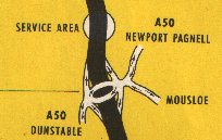
This is a simple spelling error, but because there are so few places on the map it stands out. The map is the 1959 BP strip map of the M1, and the junction with the A50 shows a second road off to Mousloe. This should of course be Moulsoe; the error may be deliberate as few users would spot the mistake. Of course this junction is now the A509 (J14), and it's Milton Keynes signposted to the West, not Dunstable! The identical error appears on the equivalent Shell strip map. |
|
|
|
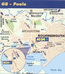
It can be a real problem for cartographers when they are required to draw detailed maps of countries far from their base. The map (left) of Poole, England is reasonably accurate and is used in the 2003 AS24 Guide to locate their station. But Fleets Bridge Roundabout is actually NW of the AS24 location, not due East, and a local would not have chosen to mark the small station at Parkstone in preference to the main station in Poole town centre. |
|
|
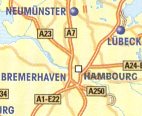
This guide does contain one clear mistake; in the 8 page Atlas Europe at the back prepared by Gabelli, one page (only) omits all place names unless they have AS24 sites. So whilst the area around Hamburg names the main city, albeit in French (top right), Berlin is accidentally left off the map completely (lower right). |
||
Forty years earlier, another French cartographer had made what was almost certainly a deliberate mistake, by naming the village of Bere Regis, around 10 miles W of Poole "Bere-Régis" with an acute accent on the second e. This was on a BP Atlas of France, prepared by IGN & Photolith (and is illustrated on one of the Quiz Pages). |
|
|
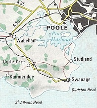
French maps showing the English Channel seem especially prone to errors. Maybe some are deliberate, but there seem to be too many on some sheets. This extract is from a 1967 Elf map of NW France, produced for them by Foldex France. Two of the 5 place names shown are wrong; it should be Wareham not "Wabeham" and Corfe Castle not "Corfe-castel". Elsewhere this map has the rather unhappy sounding "Soreham-by-Sea" and "Bringhstone" on the Isle of Wight. |
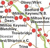
Mobil fared no better when it commissioned IGDA (Istituto Geografico de Agostini) to create the maps for its 1993 International Driver Directory - used by truck drivers holding the Routex card. Several British place names were spelled incorrectly, including Okeampton for Okehampton, Ilcester for Ilchester, Pophan for Popham, Crewel for Crewe, and Stornovay for Stornoway. But the least comprehensible error was placing the Wiltshire town of Trowbridge on the A5 where Hockliffe should be. This is marked as having a station accepting the card, though neither Trowbridge nor Hockliffe are included in the directory listing. At the time there was indeed a Mobil station on the A5 at Hockliffe, so the location is correct, but the town name is wrong. |
|
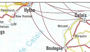
Mobil's 1984-5 Europe atlas, prepared by H. Konig for its German subsidiary which only sold lubricants, contains a curious error. The sectional maps of France at 1:1,500,000 just include the English South Coast, and show the ferry crossings across the English Channel (named as the Pas de Calais). However the English ferry terminal with routes to Boulogne and Calais is shown as being at Hythe and not Folkestone where it was in reality. Dover is just off the edge of the map to confuse users even more! |
|
|
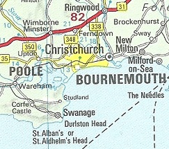
Another South Coast error from an atlas of Europe, but this time from a British Esso atlas that included all of the UK at the same scale (1:1,000,000) as the rest of the continent. Prepared by George Philip & Son Ltd, it omitted the built up area of Poole, although the square showing the centre of the area can faintly be discerned on the North edge of Poole harbour. Esso bought in the artwork from a 1972 Philips' Road Atlas, which included the same error. The area between the Western edge of Bournemouth and Upton should have been coloured yellow. |
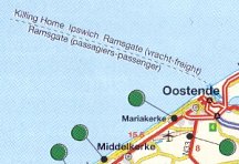
An amusing error (which may be deliberate) occurs on the 2008 map produced by de Rouck Geocart for Belgian credit card holders with Avia (shown here), Octa+, Power and Total. The ferry from Oostende (Ostend) is shown as going to Killing Home, rather than the correct Killingholme, although both would pronounced the same. Apparently this erroneous name was used by the satirical TV programme Spitting Image when the Government proposed using the town as a nuclear waste depository! |
|
Small errors in the legend of the map are sometimes easier to find. Some, if course, just reflect unusual translations, or simple spelling mistakes, which are easy to make when not working in your native language. And one recent Swiss map has part of the legend in four languages (English, French, German and Italian), but in another part repeats the German phrase 4 times.
It's always welcome to see maps recognising both miles and kilometres, but this can lead to occasional errors. The 1958 map for Caltex of Belgium (World's Fair edition) has scale lines for both km and miles; however the scales are also indicated differently as 1:640,000 (next to the km scale) and 1:400,000 (next to the mile scale). I presume that the mile one is wrong as the unnamed cartographer would have been more used to working with metric units.
Text and layout © Ian Byrne, 2006-20
All original copyrights in logos and map extracts and images are acknowledged and images are included on this site for identification purposes only.

