 An interactive map from 1920-47
A map of Britain from the archives of the National Library of Scotland
This page shows a composite map of Britain, drawn from out of copyright Ordnance Survey maps dating from 1919-1947 in the National Library of Scotland, to whom thanks are due for the ability to include it on the Petrolmaps website. The map can be zoomed in and panned in the same manner as for current maps on Google Maps, but the imagery dates from old, mainly pre-war Ordnance Survey maps. Please note that these are not oil company maps, but contain rather greater detail than was used on the inexpensive issues made available by petrol companies.
To zoom in/out easily, you can use scroll your mouse wheel forward/backward. The maximum zoom level is 1 inch to the mile (1:63,360). To pan the map, click the image once, and drag the map by holding down the left mouse button.
If you would like to know more about the map, please follow the link to the National Library of Scotland.
Comparison with a 1956 Shell Petrol Map
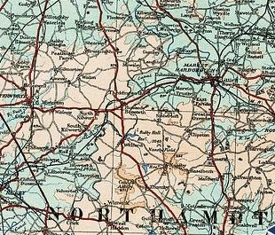
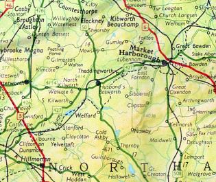
Two maps centred on the Northamptonshire village of Husbands Bosworth are shown below. In each case the extract covers the area from Rugby to Desborough (E-W) and from Kilby to Kilsby (N-S). On a modern map the M1 would run down the left hand side of the area shown, and the A14 would run East-West across the map just North of Naseby.
 This extract is from the undated composite map, and is taken from an Ordnance Survey Quarter Inch map (1:253,440). No road numbers are shown, and the National Library of Scotland say it dates from 1919-21. |
 This extract is from the 1956 Shell Midlands map. Cartography was by George Philip & Son Ltd and the original scale of the map was 6 miles to the inch (1:381,660); it has been rescaled to match the OS map shown next to it. |
Text and layout © Ian Byrne, 2010
All original copyrights in logos and map extracts and images are acknowledged and images are included on this site for identification purposes only.
