 Some special Shell maps from George Philip
In the 1960s Shellmex & BP Ltd, the UK joint venture that operated Shell, BP and National Benzole filling stations, worked very closely with George Philip & Son Ltd, one of Britain's leading map companies. Although George Philip worked for other oil companies - including Esso and, more briefly, Fina, Gulf and Jet, they appeared to have the closest relationship with the Shell group, and this is reflected in the special issues shown on the page.
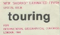
Experimenting with wipe clean maps: Shorko (1964)
Since the early 1960s, there have been a number of experimental plasticised map coatings, allowing routes to marked on maps with a "chinagraph" pencil, and subsequently erased with a damp cloth. Few of these have been widely sold, as motorists appeared unwilling to pay extra for this format, and the process generally makes maps hard to fold flat. Among the few examples know to have been commercially distributed are some Shell maps of East Africa (where the coating provided additional protection against a humid climate) and, more recently, the Belgian company Seca sold maps with a "Synteape" finish.
The map below was a special issue given away by Shell to delegates attending the International Geographic Congress in London, 1964. A normal George Philip Shell issue of Central England and Wales had been laminated by Woodman Marshall (Bookbinders) using oriented polypropylene film supplied by Shorko-Metal Box Ltd of London. Shell's interest in promoting the product was due to Shorko International, the patent holder, being a joint venture between the company and National Distillers and Chemical Corpration of America.
|
|
|
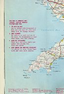
Printed in the sea to the West of Wales was the explanation
"This map is laminated with "SHORKO" biaxially oriented polypropylene film:
- THE WRITE-ON MAP
Can be marked with Chinagraph or Biro, and will then rub clean with damp cloth. No damage incurred. - HIGH FLEXIBILITY
No tendency to crack and tear at the crease. No delamination at edges when flexed. Very hard wearing. - EXCELLENT APPEARANCE
Maps show high gloss, clarity and sparkle with pleasant feel. Good sales appeal. - GOOD GREASE AND MOISTURE RESISTANCE
Not affected by water. Greasy finger marks and stains easily removed."
George Philip using the Shell trade name
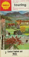
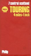
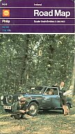
If the example above shows Shell taking advantage of its relationship with George Philip, the maps below show how the publisher was also able to benefit from its connection with the oil company. In the 1930s Philips maps were widely sold under their own name, but by the 1960s the market for cartographers' own maps had been squeezed between cheap oil company issues and larger scale maps from Bartholomews and the Ordnance Survey. So in the mid-1960s Philips sold a small number of Shell and BP maps in red or green vinyl covers respectively - the Scottish map is dated 1968. In 1969 they moved to a more attractive cover design (below) featuring a family in front of a Wolseley 16/65, parked on the edge of a wood. However, although the covers date from 1969 the maps inside were often still 1968 issues. The man shown in the photo is believed to have been an employee of George Philip.
 |
 |
 |
 |
From 1969 to 1971 Philip's maps had a purple top, and were sold for 5s. (25p) compared to 1/6d (7½p) for the paper cover issues commonly sold through Shell filling stations. Later in 1971 and 1972 they were repackaged into a red top format, with a 30p cover price compared to just 12p in paper covers, but were also available as a set in a cardboard slip case. In 1973, the designed was modified to include the simplified Shell pecten, and the photo was changed to a less well posed scene, but one which hid the identifier year on the car numberplate ("H"=1969), so that they did not look out of date.
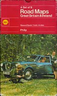
These card cover issues were produced by Philip's for their own distribution channels: it is not known if they were ever sold through Shell garages. The only example in my collection that still carries a price ticket was sold by the AA through one of its new townpoint shops - a interesting foretaste of the arrangement later in the decade when the AA supplied the cartography for Shell Supermaps that were similarly often sold away from Shell filling stations. Relatively few were printed in this format: according to George Philip's day books it appears that the total run of the 1972 edition may have been 48,200 in the card covers, compared to 760,000 in "normal" Shell paper covers (and a further 302,000 in BP or National editions).
It seems likely that the higher cover price limited their popularity, and Philip's discontinued the repackaging of the sheet maps when they introduced the new metric Shell maps at 1:200,000 in 1974. However, Philip's did continue to produce small numbers of its hardback Road Atlas of Britain in Shell, BP and National covers.

Text and layout © Ian Byrne, 2006
All original copyrights in logos and map extracts and images are acknowledged and images are included on this site for identification purposes only.