 SHELL
SHELL
Road Maps from Italy
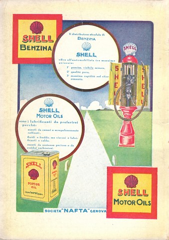
After a brief, unsuccessful foray a few years earlier, Shell started marketing in Italy in earnest in 1911. Together with Standard Oil it rapidly became a major force, a factor leading to the advancement of ENI (Agip) by the fascists in the 1930s bent on reducing Anglo-American dominance of the industry. Nonetheless, Shell prospered for many years and it was not until the 1960s that the Italian market became notoriously unprofitable. This led Shell to sell its chain to its old rival, ENI, in 1973, and the brand was soon replaced by IP. But a very few years later, Shell crept back into the market buying Conoco's Jet chain. This too had problems, so Shell merged its interests with Montedison's refining and chemicals to form MonteShell in 1987. This joint venture was broken up in the mid 1990s, with the Shell brand returning for a third time to Italy.
Maps
 |
 |
 |
 |
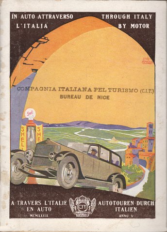
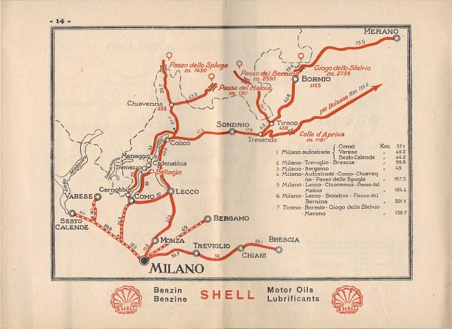
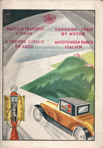
Branded pre-war oil company maps of Italy are very rare, but these two Shell map booklets carrying the English title "Through Italy by Motor" are about as close as they come. The left one dates from 1927 and one in the middle from 1930; they are marked as being from the 5th and 8th years, so it is likely other versions exist. Both were produced by Compagnia Italiana Turismo (CIT) in Rome and consist of a 32 page booklet on low quality paper and a small pasted map of Europe at the back. All pages are folded in half, to open out to a size of around 230x170mm and carry Shell advertising messages at the bottom of the page. Each booklet has around 22 pages of very basic two colour maps showing main tourist routes - the example shown (centre left) is of the area from Milan to the Swiss border, taken from the 1927 edition. The content is in four languages (Italian, French, German and English) and includes detailed advice on how to find Shell filling stations. The cover is on light card, with a full page Shell advert on the inside front cover - the 1930 example is shown above right. Inside the back cover is a folded map of Europe showing major roads.
In contrast to the oil company issue, Shell (and Esso) regularly advertised on the commonly found maps sold by the Royal Italian Auto Club (RACI) throughout the 1930s.
Post-war maps
In the early and mid 1950s, Shell initially used the international red and yellow design as in the undated Foldex example shown here with English covers. Domestically it also sold 10 sectional maps in pairs, at 1:400,000 with cartography by P.e.G. Corbellini, but still using the Foldex system. |
 |
|
 |
For 1956 it issued a small format (a little smaller than A5) booklet atlas, containing 10 double pages of maps from Officine Fotolitografiche SA of Milan at the scale of 1:1.3mn. Stylistically these were very similar to the IGDA maps used subsequently, and marked Shell Touring stations with a star. There was also a small map showing major distances in Western Europe. The inside covers were given over to a metric to imperial conversion table (including rulers for inches and cm), and a distance chart from 12 major Italian cities to border crossing points. |
|
 |
 |
 |
 |
 |
In common with many other Shell companies, Shell-Italia expanded its map range in the late 1950s. The first map above is a 1960 issue of Italy, with a typical green touring service cover. Next is a less common item, a 1959 leaflet containing basic phrases in six European languages, and including a small (1:3,000,000) map of Northern Italy and a chart showing distances to a dozen principal Italian cities from 20 different border crossings. The rear of this leaflet shows that issued a series of cartoguida (at 1:500,000), sheet maps (at 1:400,000) and city maps. A second leaflet, loose inside the first, indicated that all were for free issue except the sheet maps, and gave useful tips on visiting Italy in English, French and German.
The latter two maps are typical examples of the cartoguida and city plans. Cartoguida 7 covers Sicily (Sicilia) and the smaller format plan is of Florence (Firenze): they both date from 1961. Only the Florence map shows service station locations.
A 1958 leaflet provides three itineraries starting from Bolzano, and is one of a series of 10 such guides based on major Italian cities. Each of the three routes was roughly circular and covered between 99km and 160km. A schematic map showed where each tour went and was followed by a brief guide to the trip and a list of the gastronomic specialities of the route in four languages (Italian, English, French and German).
All the above maps were produced by Istituto Geografico de Agostini, Novara (IGDA).

|

|
1960 was the year of the Rome Olympics, and several oil companies issued special maps to aid tourists visiting the country. On the far left is a Special Olympiad plan of Rome; its reverse lists the 15 main venues in four main languages, with brief descriptions of places to visit "between events" and of Italian gastronomy. |
 Shell map of Europe") |
 |
 |
 |
 |
From 1962 onwards, Shell used its classic designs. The old sheet maps were discontinued (presumably the public could not be persuaded to pay for them when the excellent cartoguida were free!) but Shell also had an Italian version of its map of Europe (left, in its 1967 edition). The map of Italy is from 1962 at 1:1,250,000 (and not 250,000 as printed on the cover): both were again by IGDA, Novara. The "Benvenuto in Italia" booklet is a companion to the maps; like its 1959 predecessor it has a small map of Northern Italy, but instead of phrases has 3 or 4 pages of information about Italy in English, French and German. Both the Europe map and this booklet were able to quote fixed petrol prices; the former in 19 different countries (and the latter showing the reduction in Italian prices for tourists buying coupons in advance. Visitors could buy up to 15 litres per day with prepaid coupons from the A.C.I.: super grade cost 84 lire per litre against the normal price of 106 lire. Almost all Italian filling stations accepted these coupons).
The two cartoguida show the progression in design: the section 5 (centro-sud) comes from 1962 and uses the same series of drawings as the earlier style. Starting in 1964 a new, almost Fauvist, set of designs were used, as shown on this section 1 (nord-ovest). As in France, cartoguida could be bought in a set at a discounted price (600 lire in 1969); the series appears to have been discontinued after 1971.
 |
 |
Shell's large city plans were described as "pianta turistica" as the reverse was devoted to a quadrilingual list of sights. Eight cities, including Rome (far left) were covered in this series. In contrast, a further 12 cities had "pianta de attraversamento" (through plans) with a smaller format and photographic covers. The Bologna map (left) comes from 1963 and like the big city plans was produced by IGDA, Novara and locates Shell stations. |
 |
By 1969 these smaller city plans has been discontinued, with only the eight cities of Milano, Torino, Genova, Roma, Napoli, Venezia, Firenze and Palermo retained. Shell had also updated the design of its Italian map (above right), which was now at the scale of 1:1,250,000 on one side of the map, with an autostrade planning map on the reverse.
 |
 |
After the introduction of the new Shell logo in 1972, Shell had to change its map cover designs again, and produced the maps of Italy and Europe shown here. It is not known if they continued to sell cartoguides or city plans and, if so, whether they too were produced with the revised Shell symbol. Both these maps were produced by Shell's usual Italian partner of Agostini (IGDA). |
|
 |
|||
Maps: MonteshellFew maps are known from MonteShell (and none from Shell since its name was re-introduced into the Italian market). This example dates from 1986 and was jointly prepared for MonteShell, Hertz and Europ Assistance. The map was based upon Michelin map no. 988, but was printed locally on medium gloss paper by Baioni Stampa of Frascati, so it feels quite unlike a Michelin map. MonteShell's motorway sites are marked on the map, and it also carries two large adverts (in English and Italian) for the company. The format and basic design - with a stylised national flag - is however that of Hertz, as it was used in other countries without an oil company partner. |
|||

Text and layout © Ian Byrne, 2000-19
All original copyrights in logos and map extracts and images are acknowledged and images are included on this site for identification purposes only.