 TOTAL group
Total, TotalFina, AS24
Shortcuts to other brands acquired by the group:
Antar | Aquila | Azur | Elf | Fina | Minol | OZO | Stellis | Yacco
Shortcut to Total maps from outside France
Brief History
TOTAL's origins go back to 1924 when the Compagnie Française des Pétroles (CFP) was incorporated in Paris to provide a French national champion to compete with the Anglo-Saxon firms then dominating France and Europe's oil industry. Initially CFP concentrated on exploration and production of oil, mainly in the Middle East (Iraq) and, after 1933, petrol refining. Products were sold to large wholesalers such as Desmarais Frères (Azur) or Mory.
|
After the Second World War, CFP realised it needed to develop its own secure sales outlets and started the process in Africa in 1947. The first TOTAL stations in Europe came in France in 1954 (initially franchised by Azur and OZO) and the following year CFP announced its decision to start its own network and bought Aquila in Italy. In 1956 it moved into the Netherlands and in the next decade added Australia, Germany, Belgium, Austria and Britain. In the late 1950s and early 1960s it bought out Lille, Bonnières & Colombes (Stellis), Omnium Française des Pétroles (OZO) and Azur and in 1966 moved into the USA with a stake in Leonard Refineries. |
|

Maps: TOTAL
French Maps
TOTAL has never had a particularly extensive map programme, although it has issued more than its fair share of unusual or thematic maps.
 |
 |
 |
 |
 |
 |
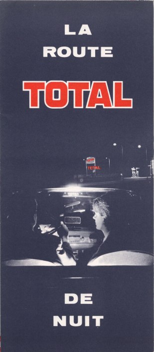
Service stations were sufficiently common in France that it was almost superfluous marking locations. However all-night stations were not common in the 1960s and the 1966 map lists just 133 (at a time when Total had over 10,000 outlets). A rudimentary map from Blondel la Rougery is included. (Enlarged image of 1969 cover, which is very slightly different, eg. in size of TOTAL lettering.) By 1977 there were 364 all-night stations and Total used a proper map by Recta-Foldex to show their locations.
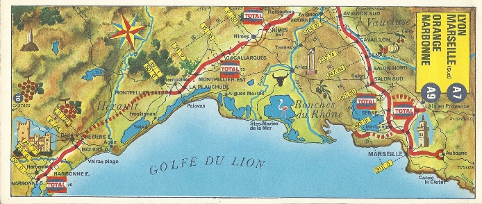
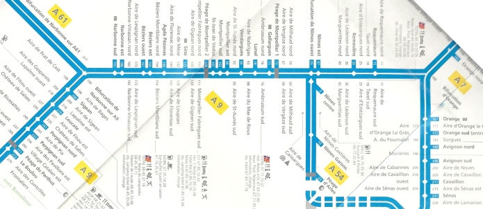
Total has always been strongly placed on the Autoroutes, and in the 70s and 80s jointly published a booklet with the road operating companies showing strip maps of the routes. Total service areas are highlighted and the examples shown date from 1972 and 1981.
 |
 |
 |
At first sight this map is not a Total map at all, as was given away free by Autoroutes du Sud de la France in 1994-5. But the small print notes that it was with the participation of Total, and the main map marks only Total stations on autoroutes or other limited access highways across the country. ASF's autoroutes are highlighted in blue; other motorways are in green, and other main roads in yellow. |
 |
 |
The reverse side contains strip maps of the ASF autoroutes (which do indicate non-Total stations, but with no logos), as well as information about the roads and the services to be found. Gabelli put the package together; the main map is at 1:1,600,000 (seen here at double size). | ||
 |
 |
 |
 |
 |
 |
The first map above shows how the Route de Nuit had become 24h/24 service by 1989; as well as manned stations it now listed stations with a "pompe automate". The next five maps of France are special titles from the mid to late 1990s. The first three promote Total's GR payment card, although the centre left one, from 1997, is aimed specifically at automated fuelling for Grand Routiers (truckers) showing GR Master locations. The left map is from 1995 and marks only autoroute and automated GR locations. The middle map, sold for 25Fr (the others were probably free) is a small format atlas with 132 pages of high quality maps and a full listing of stations taking GR cards.
The next two maps both date from 1998. The first shows LPG sites selling TOTALGAZ and the other one stadiums hosting the 1998 football World Cup. This is only in English and German (but came from a Total garage in Luxembourg!) and a French/English version also exists. Cartography differs on all 4 of the 5 maps: from L-R they are credited as CART, Media-Cartes, (anonymous, but similar to Marco Polo/EuroCart), CART and Leader Communications.
In 2003, Total took a decision to unify most stations under an updated Total image, although Elf was repositioned in France at both an upmarket supplier of oils and a chain of discount blue and yellow filling stations. No French maps are known with the new Total or Elf images, but a recent example from Total in Belgium is shown on the next page, devoted to Total maps from outside France.
Maps: AS24
 |
AS24 is the brand name used by Total on its, generally unmanned, dedicated fuelling points for commercial vehicles. AS24 is found at over 300 locations in 14 European countries (although there is only a single site in each of Belarus, Ireland and Portugal). Their sites are often located on the edge of industrial zones, or more rarely at conventional service stations (many of which are independently branded, not in the Total group). The 304 page guide contains instructions on how to use AS24 pumps in 12 languages, with detailed access and small locator maps for each outlet. The guide ends with 8 pages of small scale maps covering most of Europe prepared by Gabelli, Paris. |

Text and layout © Ian Byrne, 2000-15
All original copyrights in logos and map extracts and images are acknowledged and images are included on this site for identification purposes only.