 Petrol company maps for Expos and World's Fairs
Over the past 150 years there have been a series of World's Fairs, Universal Expositions or Expos aiming to attract visitors from many countries. Although people often arrived at these expos by air, sea or rail, most - since the 1930s, at least, have attracted a large number of motorists, and this created an opportunity for petrol companies to join in the festival spirit by creating special maps to tell them how to get to the Expo, or how to find their way around it. Indeed, several oil companies sponsored their own pavilions at some of the US expos below.
| 1933 | 1937 | 1939 | 1958 | 1962 | 1964 | 1967 | 1968 | 1992 | 1998
1933-4: Century of Progress International Exposition, Chicago
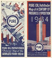
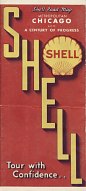
A number of oil companies issued maps in 1933 and 4 for the Century of Progress International Exposition. Pure published two versions, focusing on the fairground itself: the later one is shown here and was created for them by Rand McNally. Shell's 1934 Gousha map covered metropolitan Chicago on one side and a detailed map of the fair area on the reverse. Among other firms with maps were Barnsdall (B Square). |
|
|
1935: Exposition Universelle et Internationale, Brussels
No petrol company maps known
1937: Exposition des Arts et des Techniques, Paris
|
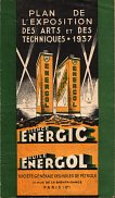
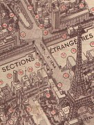
BP-Energic issued a map for the 1937 Expo in Paris. A stunning front cover reflected the competition between the Soviet and German pavilions (numbers 42 and 39 on the map), with cans of Energol replacing the buildings. Inside a half-tone map showed 3D renderings of the buildings strung along the Seine, divided in thematic areas. the extract shows the Pont d'Iéna from the Eiffel Tower to the Soviet and German exhibits in the Sections Étrangères. G Peltier drew the plan; there was also a map showing routes to the Expo from outside Paris. |
|
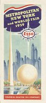
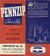
1939: New York World's Fair
The 1939 New York World's Fair was intended to celebrate the 150th anniversary of the signing of the US constitution, and took as its theme the future - epitomised by a 200ft diameter perisphere and 700ft high Trylon, which together formed the symbol shown on all the maps shown here. |
 |
 |
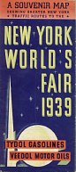 |
Fifteen large oil companies jointly sponsored a petroleum industries pavilion at the 1939 New York World's Fair, and most appear to have produced special maps. Shown here are examples from Esso, Pennzip and Tydol. Esso and Tydol provided maps of the Metropolitan New York area, with a detailed map of the fair grounds, as well as additional information on sightseeing. The Pennzip map of Ohio was overprinted for Independent Oil Co of Stillwater Ohio and on the reverse includes a small-scale map of West Virginia, a plan of the World's Fair and a US planning map. | |||
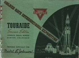
1939/40: Golden Gate International Exposition
Not to be outdone by its East Coast rival, San Francisco also hosted an expo from Feb-Oct 1939 and again the following summer. As it was on an artificial island (Treasure Island) in the Bay, adjacent to the new SF-Oakland Bay Bridge, it was considerably smaller, with a focus on the American West and only hosting around 15 international pavilions. | |
 |
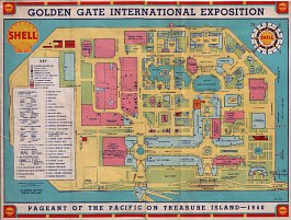 |
Although it lacked retail outlets in California, Conoco produced a special cover for its customers' Touraides. The example shown here was produced for a Mabel Johnson, and contained a return route from York, Nebraska to the Expo. Individually compiled, this Touraide contained no less than 27 map sheets, including National Parks en route as well as city plans for San Francisco and Los Angeles but - oddly, perhaps, no information about the Expo itself. Some were single sheets, backed with short descriptions of points of interest and selected lodgings, but others unfolded to reveal tinted photographs of the main attractions in the area. All the maps located settlements with Conoco service stations. In the event, Ms Johnson appears not have gone to the Expo, but instead to have used the Touraide for an August 1939 trip to the Yellowstone and Glacier National Parks. | |
1940: Grand International Exhibition of Japan (cancelled)
No petrol company maps known
1949: Exposition Internationale, Port-au-Prince
No petrol company maps known
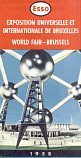
1958: Expo '58, BrusselsMaps are known from BP, Caltex, Esso, Mobil and Shell: see the special page dedicated to this Brussels expo. |
|
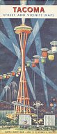
1962: Century 21 Exposition, SeattleThe 1962 exposition at Seattle is less well known, and was less well represented by oil company maps. The regional Standard Oil company (Chevron) commissioned an artist's impression of the fair by night which was used on its city maps of Seattle and, perhaps surprisingly, Tacoma. This Tacoma map had no information about the fair, and did even mark its location on the inset map of the Seattle-Tacoma area. Some firms, such as Husky, added Seattle to their map programme for 1962 to help visitors to the area, even though they had no retail outlets in the city. |
|
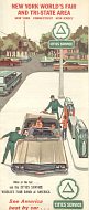
1964-5: New York World's Fair
|
|
|
|
|
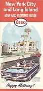
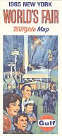
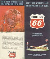
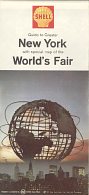
As in 1939, most of the main oil companies produced special maps of New York showing the 1964-5 World's Fair, although several - including Cities Service and Phillips 66 - kept to their normal cover design, although Phillips did include a panel about the fair on the rear cover. There was no unanimity about the main feature: Shell and Phillips featured the Unisphere, with Esso and Gulf an overall view of the Fair. Phillips and Shell included maps of Greater New York; Esso added Long Island, and Cities Services chose to term it the "Tri-State Area". All the maps above come from 1964, except for the Gulf issue which is dated 1965. | ||||
|
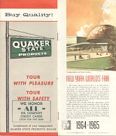
In 1964 Quaker State was a regional gasoline distributor in Western Pennsylvania and adjacent states as well as a national leader in lubricants. HM Gousha printed a 12-page booklet of information about the Fair and other sites to visit for Quaker State, with a foldout map showing the turnpikes through Pennsylvania to New York. |
|
|
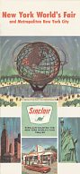
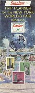
Unlike 1939, there was no single pavilion for the oil industry; Sinclair was the sole firm represented inside the showground. Its exhibit was called Sinclair Dinoland and had nine life-size fibreglass models of the dinosaurs that were (and remain) the company's trade mark. There was an attached pavilion which traced the development of oil from before the time of the dinosaurs to the present day; the exhibit proved one of the most popular at the Fair with a reported 10 million visitors. Eight of the dinosaurs survive to this day at various locations across the USA. |
|||
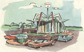
Sinclair's New York area map by Rand McNally was backed by a large scale plan of the fair, with insets describing Dinoland and showing the company's futuristic gas stations in the car park and marina. Sinclair also published a 20 page booklet that included a checklist of exhibits to see at the Fair, and information about other sites to visit in the Greater New York area. |
 |
||
1967: Expo '67, Montreal
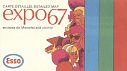
Expo 67 was Canada's answer to the US fairs of the 1960s. Imperial Oil (Esso) produced a plan of the fairground, drawn by the General Drafting Co., marking its 12 official information booths. |
|
|
|
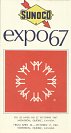
Sunoco also produced a couple of maps; this plan of the fairground in a convenient vest pocket size was produced by the leading Canadian cartographer, Rolph Clark Stone. |
|||
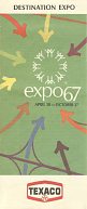
Texaco's map - produced by US firm HM Gousha - was called "Destination Expo" as it had no plan of the event. Instead, its 3 maps covered the greater Montreal area, a small scale map of the St Laurence river valley, and a strip map of Highway 401 from Windsor to Montreal. |
|||
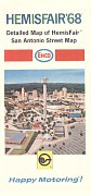
1968: Hemisfair, San AntonioAlthough it is not officially regarded as an Expo, the Hemisfair held in 1968 in San Antonio, Texas had many of the same features, including a road map issued especially for the event by Enco, the regional brand name used at the time by Humble Oil & Refining Co (Esso in Europe). A large scale map of the city was backed by a plan of the fair, with limited information about the attractions, which included the Humble Pavilion, which was in a restored Victorian warehouse (the Schultze building). No other oil companies appear to have marked Hemisfair. |
|
1970: Expo 70, Osaka
Mitsubishi Oil is known to have issued a map for this expo.
After the international optimism of the 1960s, the next couple of decades saw greater austerity and inflation initially brought on by sharp oil price rises of 1972-3. Large scale international expos fell out of fashion, although Exxon did co-sponsor a map for the so-called 1984 Louisiana World Exposition. And by the time that they were revived in 1992, by a newly confident Spanish Government keen to promote itself as a vibrant modern democracy, most oil companies had stopped issuing branded maps in their main markets.
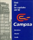
1992: Expo '92, Seville
|
1992 was an important year for Spain, representing the 500th anniversary of Columbus's voyage to North America. To commemorate this event, it hosted the Olympics in Barcelona and mounted an international Expo in Sevilla. The Campsa guide included an additional book, produced in rather garish colours, giving practical information for visitors to these two cities and the European capital of culture for 1992, Madrid. It included 6 fold-out maps/plans - one for each city (lacking most street names and drawn in perspective), plus plans of the Olympic stadium, route of the Olympic torch and Expo 92 grounds. |
|
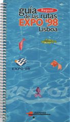
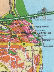
1998: Expo '98 Lisboa (Lisbon)
|
Repsol is the largest post-liberalisation entrant to the Portuguese fuel market. It sold a 300 page spiral bound guide based around Routes to the Expo '98 in Lisbon, which included hotels, restaurants and places of interest along the routes. There were also fold out maps of Portugal (marking Repsol locations), a guide to the Expo itself, an extended section describing all the main attractions in Lisbon itself and a short guide to Portuguese wine. |
|
Most Recent Expos
No maps are known for the following recent expos:
2000: Expo 2000, Hannover
2005: Expo 2005, Aichi, Japan
2010: Expo 2010, Shanghai
Earlier Expos
For completeness, the earlier official world expos, for which no petrol maps were produced, include:
1851: Great Exhibition, London
1853: New York Expo
1855: Exposition Universelle, Paris
1862: International Exhibition, London
1867: Exposition Universelle, Paris
1873: Weltausstellung, Vienna
1876: Centennial Exposition, Philadelphia
1878: Exposition Universelle, Paris
1889: Exposition Universelle, Paris
1893: World's Columbian Exhibition, Chicago
1900: Exposition Universelle, Paris
1904: Louisiana Purchase Exposition, St. Louis
1915: Panama-Pacific International Exposition, San Francisco
1925: Exposition Internationale des Arts Decoratifs et Industriels Modernes, Paris
1926: Sesquicentennial Exposition, Philadelphia
1929: Ibero-American Exhibition, Seville
Maps were however produced for a number of smaller American expositions. As well as the 1984 Louisiana event mentioned above, maps have been issued for such diverse events as the Canadian National Exhibition in the late 1950s (Shell), the Oregon Centennial Exposition and international trade fair in 1959 (Chevron), the Los Angeles County Fair (Chevron, again) and the 1986 Vancouver Expo (Texaco).
Note on the American brands not shown elsewhere on this websiteSome of the brands shown on this page are not represented elsewhere on this website, as they only had limited operations in Europe. |

Text and layout © Ian Byrne, 2004-11
All original copyrights in logos and map extracts and images are acknowledged and images are included on this site for identification purposes only.