 MOBIL
MOBIL
Mobilgas
There are separate pages showing maps from Great Britain and France.
Brief History
|
Vacuum Oil Company was established in the USA in 1866 and acquired by the Standard Oil combine in 1879. It started selling lubricating oils in Europe in the late 19th century and rapidly became one of the main brands, sold also by other Standard subsidiaries. Domestically, Vacuum started acquiring petrol (gasoline) distributors in the 1920s, and it appears to have done likewise in Europe at much the same time. It appears as if Vacuum was restricted to the Eastern and Western flanks of Europe, with Anglo-American (Esso) concentrating on the main Western European markets. After the 1931 merger with Standard Oil Company of New York (Socony), the local brands were gradually replaced by the Mobilgas identity. Mobil was still absent from several countries until after World War II, and by the 1970s was available across Western Europe except for Ireland, Finland and West Germany, where it owned 30% of Aral, the market leader. |
|

Maps: Vacuum subsidiaries - Auto-Gazo and Sphinx
 |
 |
The map shown far left is a late 1920s set of four small maps of Portugal in a slip case advertising Vacuum Oil Company's Auto-Gazo petrol and Mobiloil lubricants. A close up of the image can be found on the Portugal page. |
Maps: Mobilgas/Mobil

|
 |
") |
Austria was one of Mobil's strongest markets. The oldest map shown here dates from the early to mid-1950s, when the country was still partitioned and Mobil products were not on sale in the Russian zone. This can be clearly seen from the way Mobilgas stations are not marked in the East of the country. The other two maps date from the early 1960s, by which time Mobil products were once again on sale throughout the country including Vienna (Wien). |
|
This Austrian map is thought to be from 1959. The main map, at 1:600,000, is by Freytag-Berndt and marks and lists all Mobil stations. The reverse contains four pictorial strip maps, with the text turning upside down between Klagenfurt and Villach! Großtankstellen are marked in the main towns. |
|


|
Also carrying a 1959 date on the artwork, this small map of Western Austria opened out to a sheet just 41 x 29cm. Piller Druck of Wien produced the fairly basic map at a scale of 1:800,000, which underlined towns or villages with Mobil stations. |

 |
 |
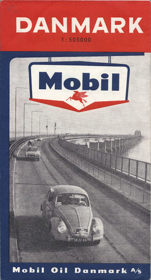
Mobil built up a relatively strong presence in Scandinavia. Neither of the maps shown here are dated, but from style (and logo) both would appear to be from the early 1960s. The Danish map, at the characteristic scale of 1:505,000, features a Volkswagen beetle competing in the Mobil Economy Run crossing the Storstrom Bridge connecting the islands of Falster and Sjælland, being followed by a Ford Taunus of a model sold between 1960 and 1964. J.S.Jensens provided the cartography, which gave great prominence to wooded areas. |
 |
|
 |
 Agostini (IGDA) of Novara produced a number of maps for Mobil in Italy. Far Left is a 1958 map of the entire country in light card covers, and left two sections from a 1964/6 small format series of 8 covering the country at a scale of 1:750,000. These small maps were sold for Lit.60 each and had town plans, showing the location of Mobil stations, on the reverse.
|
Mobil was one of just five brands (and the only American one) available in Portugal until recent years. In 1948 Mobiloil divided Portugal into four sections North to South (left). Only the final section is dated. Right is a May 1960 map of Portugal produced in English and French for intrepid tourists! Only 20,000 copies were printed by Bertrand (Irmãos) Limitada of this rare map which marked Mobil outlets and had inset maps for Porto and Lisboa. The reverse cover was in English with a photo of the Monument to the Discoveries (shown on introductory page). |
|


|
These two Mobil maps date from the early 1960s and were both prepared by Kümmerley & Frey, based in Switzerland (left). Mobil maps of Europe are much less common than equivalent maps from the other main petrol companies. This 1964 example has a planning map on one side at the rather small scale of 1:4,320,000 omitting almost all of Scandinavia; the reverse side is given over to 28 city plans, including locations such as Manchester, Luxembourg and Istanbul. The copy shown here has had the Mobil logo overstamped by H Bobinsky & Co, who operated a Mobil service station in the SW suburbs of Vienna (Wien); it is not thought that this map was available in the UK. |
|


Mobil was traditionally strong in Greece, Cyprus and Turkey, where it was the main Standard Oil company. Additional images are shown on the linked country pages. |
 |

|
 |
 |
 |
 |
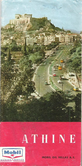
Left is a May 1963 map of Greece at 1:1,170,000 backed by a planning map of Europe with 26 flags of European countries along the bottom. The map was sold for 10 drachmas. Next is an undated map of Athens, probably given away around 1960. Although quite basic, it includes a map of central Athens plus a couple of insets of the surrounding area, and also lists all the Mobil stations (fuel only or with service). In the centre is a 1967 map of the island of Corfu (Kerkyra) with a delightfully homespun cover of a toy Mobil garage and two toy cars. The toy garage is Manessi Bros.' and the map says "phone 3-70 and a driver will call to collect your car for servicing at Corfu's new Mobil Service Station" - in 5 languages! The map is also basic, but includes tourist information and a list of hotels and casinos. In contrast the 1980s (?) sectional map 3/4 has excellent cartography by D. Tsopelas and was sold as a set of 4 maps in a rigid PVC wallet with an insert booklet listing all hotels and selected campsites.
Athens image courtesy of Stan DeOrsey.
|
|
On the left are two more recent maps in the international Mobil style. The map of Austria is undated but probably from the 1970s. Produced by Rudolf Hautzinger it marks all towns and villages with Mobil stations and unusually splits Austria across the two sides. Like most Austrian maps it has inset maps of the chief towns of Länder. |


Finally, two road atlases. The one shown below left dates from 1970 and has 66 pages of maps by Mobil's regular US cartographer, Rand McNally, mainly at 1:1,500,000. Although the text is in English, French, German and Italian, the copy shown here was sold by a Greek Mobil station.
|
In contrast the hardback road atlas prepared in 1984-5 by Institut H. König for Mobil Oil Deutschland does not appear to have been sold in other countries. As Mobil only sold lubricants in West Germany, it is possible that the atlas was used for an on-pack promotion with oil. The cover is slightly misleading; although it says "Deutschland 1:400 000", only West Germany was at this scale (as, in fact, were Switzerland and Austria), with the GDR at 1:1 million. Benelux and France were also covered at an intermediate scale. |
|


Text and layout © Ian Byrne, 1999-2014
All original copyrights in logos and map extracts and images are acknowledged and images are included on this site for identification purposes only.